Sainte-Feyre-la-Montagne | |
|---|---|
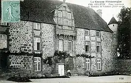 The Château of Villefort | |
Location of Sainte-Feyre-la-Montagne | |
 Sainte-Feyre-la-Montagne  Sainte-Feyre-la-Montagne | |
| Coordinates: 45°53′59″N 2°14′00″E / 45.8997°N 2.2333°E | |
| Country | France |
| Region | Nouvelle-Aquitaine |
| Department | Creuse |
| Arrondissement | Aubusson |
| Canton | Felletin |
| Intercommunality | CC Creuse Grand Sud |
| Government | |
| • Mayor (2020–2026) | Claude Bialoux[1] |
| Area 1 | 6.84 km2 (2.64 sq mi) |
| Population | 120 |
| • Density | 18/km2 (45/sq mi) |
| Time zone | UTC+01:00 (CET) |
| • Summer (DST) | UTC+02:00 (CEST) |
| INSEE/Postal code | 23194 /23500 |
| Elevation | 540–688 m (1,772–2,257 ft) |
| 1 French Land Register data, which excludes lakes, ponds, glaciers > 1 km2 (0.386 sq mi or 247 acres) and river estuaries. | |
Sainte-Feyre-la-Montagne (French pronunciation: [sɛ̃t fɛʁ la mɔ̃taɲ]; Occitan: Sent Afeiran la Montanha) is a commune in the Creuse department in central France.
Population
| Year | Pop. | ±% |
|---|---|---|
| 1962 | 133 | — |
| 1968 | 138 | +3.8% |
| 1975 | 133 | −3.6% |
| 1982 | 144 | +8.3% |
| 1990 | 144 | +0.0% |
| 1999 | 122 | −15.3% |
| 2008 | 118 | −3.3% |
See also
References
- ↑ "Répertoire national des élus: les maires" (in French). data.gouv.fr, Plateforme ouverte des données publiques françaises. 13 September 2022.
- ↑ "Populations légales 2021". The National Institute of Statistics and Economic Studies. 28 December 2023.
Wikimedia Commons has media related to Sainte-Feyre-la-Montagne.
This article is issued from Wikipedia. The text is licensed under Creative Commons - Attribution - Sharealike. Additional terms may apply for the media files.