Úmyslovice | |
|---|---|
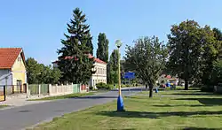 Centre of Úmyslovice | |
 Flag  Coat of arms | |
 Úmyslovice Location in the Czech Republic | |
| Coordinates: 50°12′12″N 15°10′40″E / 50.20333°N 15.17778°E | |
| Country | |
| Region | Central Bohemian |
| District | Nymburk |
| First mentioned | 1291 |
| Area | |
| • Total | 6.24 km2 (2.41 sq mi) |
| Elevation | 187 m (614 ft) |
| Population (2023-01-01)[1] | |
| • Total | 314 |
| • Density | 50/km2 (130/sq mi) |
| Time zone | UTC+1 (CET) |
| • Summer (DST) | UTC+2 (CEST) |
| Postal code | 290 01 |
| Website | www |
Úmyslovice is a municipality and village in Nymburk District in the Central Bohemian Region of the Czech Republic. It has about 300 inhabitants.
Administrative parts
The village of Ostrov is an administrative part of Úmyslovice.
Geography
Úmyslovice is located about 9 kilometres (6 mi) east of Nymburk and 46 km (29 mi) east of Prague. It lies in a flat agricultural landscape in the Central Elbe Table.
History
The first written mention of Úmyslovice is from 1291. The village continuously belonged to the Poděbrady estate until the establishment of the independent municipality in 1850.[2]
Sights
The landmark of Úmyslovice is the Church of Saint Leonard. The church was built in 1729–1732, then it was completely rebuilt in the Neoclassical style in 1812. Neogothic modifications were made at the end of the 19th century.[3]
References
- ↑ "Population of Municipalities – 1 January 2023". Czech Statistical Office. 2023-05-23.
- ↑ "Historie" (in Czech). Obec Úmyslovice. Retrieved 2023-03-03.
- ↑ "Kostel sv. Linharta" (in Czech). National Heritage Institute. Retrieved 2023-03-03.