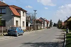
Kněžice | |
|---|---|
 Western part of Kněžice | |
 Kněžice Location in the Czech Republic | |
| Coordinates: 50°15′26″N 15°20′8″E / 50.25722°N 15.33556°E | |
| Country | |
| Region | Central Bohemian |
| District | Nymburk |
| First mentioned | 1295 |
| Area | |
| • Total | 19.58 km2 (7.56 sq mi) |
| Elevation | 223 m (732 ft) |
| Population (2023-01-01)[1] | |
| • Total | 548 |
| • Density | 28/km2 (72/sq mi) |
| Time zone | UTC+1 (CET) |
| • Summer (DST) | UTC+2 (CEST) |
| Postal code | 289 02 |
| Website | www |
Kněžice is a municipality and village in Nymburk District in the Central Bohemian Region of the Czech Republic. It has about 500 inhabitants.
Administrative parts
Villages of Dubečno and Osek are administrative parts of Kněžice.
Geography
Kněžice is located about 22 kilometres (14 mi) east of Nymburk and 60 km (37 mi) east of Prague. It lies mostly in the Central Elbe Table. The eastern part of the municipal territory lies in the East Elbe Table and includes the highest point of Kněžice, the Na Pískách hill at 292 m (958 ft) above sea level. The Záhornický Stream originates here and flows across the municipality.
History
The first written mention of Kněžice is from 1295.[2]
Sights
The most important monument is the Church of Saints Peter and Paul. It was built in the Baroque style in the 1780s.[3]
Gallery
 Church of Saints Peter and Paul
 Záhornický Stream
 The village of Dubečno
References
- ↑ "Population of Municipalities – 1 January 2023". Czech Statistical Office. 2023-05-23.
- ↑ "Historie obce" (in Czech). Obec Kněžice. Retrieved 2022-02-25.
- ↑ "Kostel sv. Petra a Pavla" (in Czech). National Heritage Institute. Retrieved 2023-07-04.