Chotěšice | |
|---|---|
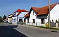
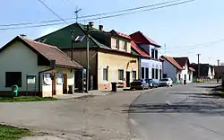 Main street | |
 Flag  Coat of arms | |
 Chotěšice Location in the Czech Republic | |
| Coordinates: 50°16′43″N 15°16′23″E / 50.27861°N 15.27306°E | |
| Country | |
| Region | Central Bohemian |
| District | Nymburk |
| First mentioned | 1199 |
| Area | |
| • Total | 22.51 km2 (8.69 sq mi) |
| Elevation | 213 m (699 ft) |
| Population (2023-01-01)[1] | |
| • Total | 330 |
| • Density | 15/km2 (38/sq mi) |
| Time zone | UTC+1 (CET) |
| • Summer (DST) | UTC+2 (CEST) |
| Postal code | 289 01 |
| Website | www |
Chotěšice is a municipality and village in Nymburk District in the Central Bohemian Region of the Czech Republic. It has about 300 inhabitants.
Administrative parts
Villages of Břístev, Malá Strana, Nouzov and Nová Ves are administrative parts of Chotěšice.
Geography
Chotěšice is located about 19 kilometres (12 mi) northeast of Nymburk and 53 kilometres (33 mi) northeast of Prague. It lies in the Central Elbe Table lowland. The Smíchovský Stream flows through the municipality.
History
The first written mention of Chotěšice is in a deed of King Ottokar I of Bohemia from 1199.[2]
Sights
The landmark of Chotěšice is the Church of the Sending of the Holy Apostles. It was first mentioned in the 14th century and rebuilt in the Renaissance style in 1599.[2]
Gallery
 Main street with the municipal office
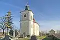 Church of the Sending of the Holy Apostles
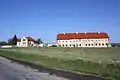 Old barn
References
- ↑ "Population of Municipalities – 1 January 2023". Czech Statistical Office. 2023-05-23.
- 1 2 "Obec Chotěšice" (in Czech). Obec Chotěšice. Retrieved 2022-08-25.
External links
Wikimedia Commons has media related to Chotěšice.
This article is issued from Wikipedia. The text is licensed under Creative Commons - Attribution - Sharealike. Additional terms may apply for the media files.