Abdanan County
Persian: شهرستان آبدانان | |
|---|---|
County | |
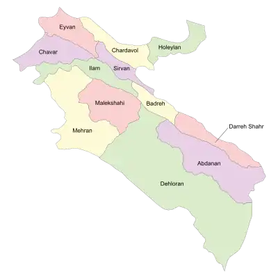 Location of Abdanan County in Ilam province (right, purple) | |
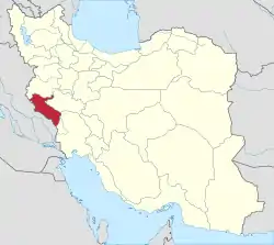 Location of Ilam province in Iran | |
| Coordinates: 32°50′N 47°30′E / 32.833°N 47.500°E[1] | |
| Country | |
| Province | Ilam |
| Capital | Abdanan |
| Districts | Central, Kalat, Sarab Bagh |
| Population (2016)[2] | |
| • Total | 47,851 |
| Time zone | UTC+3:30 (IRST) |
| Abdanan County can be found at GEOnet Names Server, at this link, by opening the Advanced Search box, entering "9205929" in the "Unique Feature Id" form, and clicking on "Search Database". | |
Abdanan County (Persian: شهرستان آبدانان, Kurdish: ئاودانان) is in Ilam province, Iran. Its capital is the city of Abdanan.[3] The county is populated by Kurds and Lurs.[4]
At the 2006 census, the county's population was 45,830 in 9,358 households.[5] The following census in 2011 counted 46,977 people in 11,256 households.[6] At the 2016 census, the county's population was 47,851 in 13,188 households.[2]
Administrative divisions
The population history and structural changes of Abdanan County's administrative divisions over three consecutive censuses are shown in the following table. The latest census shows three districts, six rural districts, and three cities.[2]
| Administrative Divisions | 2006[5] | 2011[6] | 2016[2] |
|---|---|---|---|
| Central District | 28,916 | 29,499 | 34,734 |
| Jaber-e Ansar RD | 4,527 | 4,415 | 8,585 |
| Masbi RD | 2,727 | 2,183 | 2,203 |
| Abdanan (city) | 21,662 | 22,901 | 23,946 |
| Kalat District | 6,812 | 6,614 | 6,847 |
| Abanar RD | 2,149 | 2,158 | 2,119 |
| Murmuri RD | 1,172 | 927 | 960 |
| Murmuri (city) | 3,491 | 3,529 | 3,768 |
| Sarab Bagh District | 10,102 | 10,643 | 6,270 |
| Cham Kabud RD | 5,424 | 5,539 | |
| Sarab Bagh RD | 4,678 | 2,547 | 2,611 |
| Vach Kabud RD | 1,000 | ||
| Sarabbagh (city) | 2,557 | 2,659 | |
| Total | 45,830 | 46,977 | 47,851 |
| RD: Rural District | |||
Wikimedia Commons has media related to Abdanan County.
References
- ↑ OpenStreetMap contributors (1 June 2023). "Abdanan County" (Map). OpenStreetMap. Retrieved 1 June 2023.
- 1 2 3 4 "Census of the Islamic Republic of Iran, 1395 (2016)". AMAR (in Persian). The Statistical Center of Iran. p. 16. Archived from the original (Excel) on 1 November 2020. Retrieved 19 December 2022.
- ↑ Gitashenasi Province Atlas of Iran
اطلس گیتاشناسی استانهای ایران Archived 2007-05-22 at the Wayback Machine - ↑ Aliakbari, Mohammad; Gheitasi, Mojtaba; Anonby, Erik (2015). "On Language Distribution in Ilam Province, Iran". Iranian Studies. 48 (6): 835–850. doi:10.1080/00210862.2014.913423. S2CID 162337795.
- 1 2 "Census of the Islamic Republic of Iran, 1385 (2006)". AMAR (in Persian). The Statistical Center of Iran. p. 16. Archived from the original (Excel) on 20 September 2011. Retrieved 25 September 2022.
- 1 2 "Census of the Islamic Republic of Iran, 1390 (2011)" (Excel). Iran Data Portal (in Persian). The Statistical Center of Iran. p. 16. Retrieved 19 December 2022.
Ilam province, Iran | ||||||||||||||||||||||||
|---|---|---|---|---|---|---|---|---|---|---|---|---|---|---|---|---|---|---|---|---|---|---|---|---|
Capital: Ilam | ||||||||||||||||||||||||
| Counties and cities |
|  | ||||||||||||||||||||||
| Sights |
| |||||||||||||||||||||||
| Populated places | ||||||||||||||||||||||||
| Capital | |||||||||||||||||||||||||||||||
|---|---|---|---|---|---|---|---|---|---|---|---|---|---|---|---|---|---|---|---|---|---|---|---|---|---|---|---|---|---|---|---|
| Districts |
| ||||||||||||||||||||||||||||||
This article is issued from Wikipedia. The text is licensed under Creative Commons - Attribution - Sharealike. Additional terms may apply for the media files.