Ilam County
Persian: شهرستان ایلام | |
|---|---|
County | |
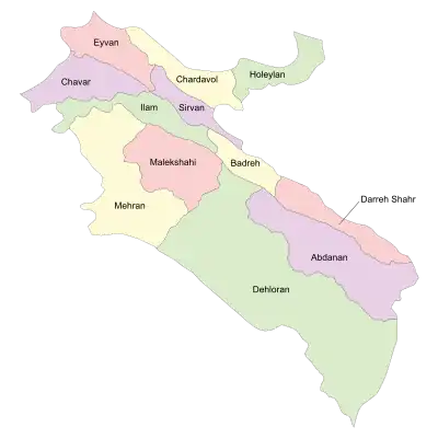
 Location of Ilam County in Ilam province (top center, green) | |
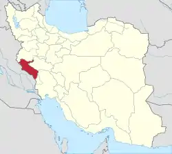
 Location of Ilam province in Iran | |
| Coordinates: 33°34′N 46°27′E / 33.567°N 46.450°E[1] | |
| Country | |
| Province | Ilam |
| Capital | Ilam |
| Districts | Central, Sivan |
| Population (2016)[2] | |
| • Total | 235,144 |
| Time zone | UTC+3:30 (IRST) |
| Ilam County can be found at GEOnet Names Server, at this link, by opening the Advanced Search box, entering "9205930" in the "Unique Feature Id" form, and clicking on "Search Database". | |
Ilam County (Persian: شهرستان ایلام) is in Ilam province, Iran. Its capital is the city of Ilam.
At the 2006 census, the county's population was 193,222 in 42,207 households.[3] The following census in 2011 counted 213,579 people in 52,391 households.[4] At the 2016 census, the county's population was 235,144 in 64,671 households,[2] by which time Mishkhas Rural District had been separated from the Central District in the establishment of Sivan District.[5]
Administrative divisions
The population history and structural changes of Ilam County's administrative divisions over three consecutive censuses are shown in the following table. The latest census shows three districts, six rural districts, and two cities.[2]
In 2019, the village of Jafarabad was elevated to the status of a city.[6] In November 2019, Chavar District was separated from the county in the establishment of Chavar County.[7]
In 2023, Alishervan Rural District was transferred to the Central District of Badreh County. In the same year, Mahmudabad Rural District was established in Sivan District.[8]
| Administrative Divisions | 2006[3] | 2011[4] | 2016[2] |
|---|---|---|---|
| Central District | 181,362 | 201,523 | 215,543 |
| Deh Pain RD | 16,909 | 19,898 | 13,726 |
| Keshvari RD | 7,787 | ||
| Mishkhas RD | 9,164 | 9,412 | |
| Ilam (city) | 155,289 | 172,213 | 194,030 |
| Chavar District1 | 11,860 | 11,710 | 10,554 |
| Arkavazi RD | 4,640 | 4,384 | 3,702 |
| Boli RD | 1,646 | 1,551 | 1,021 |
| Chavar (city) | 5,574 | 5,775 | 5,831 |
| Sivan District | 8,994 | ||
| Alishervan RD2 | 1,767 | ||
| Mahmudabad RD3 | |||
| Mishkhas RD | 7,227 | ||
| Jafarabad (city)4 | |||
| Total | 193,222 | 213,579 | 235,144 |
| RD: Rural District 1Became a part of Chavar County after the 2016 census[7] 2Transferred to Badreh County after the 2016 census[8] 3Established after the 2016 census[8] 4Became a city after the 2016 census[6] | |||
References
- ↑ OpenStreetMap contributors (6 June 2023). "Ilam County" (Map). OpenStreetMap. Retrieved 6 June 2023.
- 1 2 3 4 "Census of the Islamic Republic of Iran, 1395 (2016)". AMAR (in Persian). The Statistical Center of Iran. p. 16. Archived from the original (Excel) on 1 November 2020. Retrieved 19 December 2022.
- 1 2 "Census of the Islamic Republic of Iran, 1385 (2006)". AMAR (in Persian). The Statistical Center of Iran. p. 16. Archived from the original (Excel) on 20 September 2011. Retrieved 25 September 2022.
- 1 2 "Census of the Islamic Republic of Iran, 1390 (2011)" (Excel). Iran Data Portal (in Persian). The Statistical Center of Iran. p. 16. Retrieved 19 December 2022.
- ↑ "Approval letter regarding the country divisions of Ilam province". Islamic Parliament Research Center of the Islamic Republic of Iran (in Persian). 11 December 2013. Archived from the original on 23 August 2013. Retrieved 7 June 2023.
- 1 2 "The approval of the Minister of Interior with the establishment of Jafarabad municipality in Ilam province". Borna News (in Persian). Ministry of Interior. 26 August 2019. Archived from the original on 12 November 2023. Retrieved 12 November 2023.
- 1 2 Jahangiri, Ishaq (8 November 2019). "Letter of approval regarding country divisions in Ilam County, Ilam province". Qavanin (in Persian). Ministry of Interior, Council of Ministers. Archived from the original on 17 November 2022. Retrieved 4 June 2023.
- 1 2 3 Mokhbar, Mohammad (5 April 2023). "Letter of approval regarding the country divisions of Ilam province" (PDF). RRK (in Persian). Ministry of Interior, Board of Ministers. Archived from the original (PDF) on 21 April 2023. Retrieved 12 November 2023.
