| Battle of the Sink Hole | |||||||
|---|---|---|---|---|---|---|---|
| Part of American Indian Wars and War of 1812 | |||||||
 Site of the battle was in Lincoln County, Missouri | |||||||
| |||||||
| Belligerents | |||||||
| Sauk |
Missouri Rangers | ||||||
| Commanders and leaders | |||||||
| Black Hawk |
Peter Craig | ||||||
| Strength | |||||||
| Band | Company | ||||||
| Casualties and losses | |||||||
| 1 killed |
8 killed 5 wounded 1 missing | ||||||


The Battle of the Sink Hole was fought on May 24, 1815, after the official end of the War of 1812, between Missouri Rangers and Sauk Indians led by Black Hawk. According to Robert McDouall, the British commander in the area, the Sauk had not received official word from the British that the Treaty of Ghent had ended the war with the U.S.
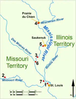
The battle was fought in a low spot near the mouth of the Cuivre River in Missouri, site of the present-day city of Old Monroe in what is now Lincoln County near Fort Howard and Fort Cap au Gris. An ambush by the Sauk of a company of rangers led to a prolonged siege: seven Rangers (including their commander, Captain Peter Craig) and one Sauk were killed. Conflicting accounts of the action were given by John Shaw[1] and by Black Hawk.[2]
After the battle, in 1816 Black Hawk entered into negotiations with the US government, ultimately reaffirming the Treaty of St. Louis.[3]
References
- ↑ Stevens, Walter B. (1921). Centennial History of Missouri (The Center State) /One Hundred Years in the Union. St. Louis: S. J. Clarke.
- ↑ Black Hawk (1916) [1834]. Milo M. Quaife (ed.). Life of Black Hawk, Ma-ka-tai-me-she-kia-kiak. Chicago: Lakeside Press. pp. 66–68.
- ↑ "Black Hawk: Resisting American Expansion". Eighteen Twelve (Canada). Archived from the original on 2018-10-04. Retrieved 2020-06-25.
External links
- Geology of the War of 1812: Terrain Influences on the Battle of the Sink Hole, Missouri Territory
- Michael Dickey, "The Forgotten War: Missouri from 1812-1815", Friends of Arrow Rock website, September 2013
- Battle of Sinkhole - Missouri Speleological Survey (Publication)
38°56′00″N 90°41′13″W / 38.933384°N 90.687068°W