Cook
Queensland
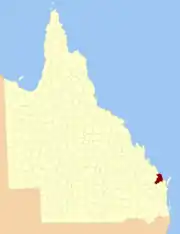
Location within Queensland
Lands administrative divisions around Cook:
Flinders Coral Sea Coral Sea
Bowen Cook Coral Sea
Mackenzie Lennox March

The county of Cook is a cadastral division of Queensland, centred on the city of Bundaberg,[1] and its name honours Captain James Cook. It was officially named and bounded by the Governor in Council on 7 March 1901 under the Land Act 1897.[2]

Parishes

Cook is divided into parishes, as listed below:

ParishLGACoordinatesTowns
BarnsBundaberg25°01′S 152°26′E / 25.017°S 152.433°E / -25.017; 152.433 (Barns Parish)
BarolinBundaberg24°50′S 152°26′E / 24.833°S 152.433°E / -24.833; 152.433 (Barolin Parish)Bargara, Burnett Heads, Elliott Heads
BingeraBundaberg25°02′S 152°16′E / 25.033°S 152.267°E / -25.033; 152.267 (Bingera Parish)
BooyalBundaberg25°09′S 152°03′E / 25.150°S 152.050°E / -25.150; 152.050 (Booyal Parish)Booyal
BroomfieldNorth Burnett25°27′S 152°12′E / 25.450°S 152.200°E / -25.450; 152.200 (Broomfield Parish)
BundabergBundaberg24°56′S 152°20′E / 24.933°S 152.333°E / -24.933; 152.333 (Bundaberg Parish)Bundaberg, Avoca, Branyan
BurrumFraser Coast25°19′S 152°32′E / 25.317°S 152.533°E / -25.317; 152.533 (Burrum Parish)Howard
CherwellFraser Coast25°16′S 152°28′E / 25.267°S 152.467°E / -25.267; 152.467 (Cherwell Parish)
ChildersBundaberg25°15′S 152°18′E / 25.250°S 152.300°E / -25.250; 152.300 (Childers Parish)Childers
ChoweyNorth Burnett25°28′S 151°52′E / 25.467°S 151.867°E / -25.467; 151.867 (Chowey Parish)Didcot
CoringaNorth Burnett25°21′S 151°57′E / 25.350°S 151.950°E / -25.350; 151.950 (Coringa Parish)
DallarnilNorth Burnett25°22′S 152°04′E / 25.367°S 152.067°E / -25.367; 152.067 (Dallarnil Parish)Dallarnil
DegilboNorth Burnett25°31′S 151°57′E / 25.517°S 151.950°E / -25.517; 151.950 (Degilbo Parish)Biggenden, Degilbo
ElectraBundaberg25°04′S 152°08′E / 25.067°S 152.133°E / -25.067; 152.133 (Electra Parish)
EurekaBundaberg25°18′S 152°10′E / 25.300°S 152.167°E / -25.300; 152.167 (Eureka Parish)
GooburrumBundaberg24°47′S 152°20′E / 24.783°S 152.333°E / -24.783; 152.333 (Gooburrum Parish)Bundaberg North, Gooburrum
GregoryBundaberg25°09′S 152°16′E / 25.150°S 152.267°E / -25.150; 152.267 (Gregory Parish)Cordalba
HerculesBundaberg25°09′S 152°35′E / 25.150°S 152.583°E / -25.150; 152.583 (Hercules Parish)Woodgate (S)
IsisBundaberg25°11′S 152°27′E / 25.183°S 152.450°E / -25.183; 152.450 (Isis Parish)Buxton
KalkieBundaberg24°54′S 152°24′E / 24.900°S 152.400°E / -24.900; 152.400 (Kalkie Parish)Bundaberg East, Kalkie, Walkervale
KinaginBundaberg24°50′S 152°01′E / 24.833°S 152.017°E / -24.833; 152.017 (Kinagin Parish)
KolboreFraser Coast25°20′S 152°25′E / 25.333°S 152.417°E / -25.333; 152.417 (Kolbore Parish)
KullogumBundaberg25°21′S 152°16′E / 25.350°S 152.267°E / -25.350; 152.267 (Kullogum Parish)
MarathonBundaberg25°06′S 152°26′E / 25.100°S 152.433°E / -25.100; 152.433 (Marathon Parish)Goodwood, Woodgate (N)
MungoreNorth Burnett25°35′S 152°04′E / 25.583°S 152.067°E / -25.583; 152.067 (Mungore Parish)
North KolanBundaberg24°47′S 152°12′E / 24.783°S 152.200°E / -24.783; 152.200 (North Kolan Parish)
OtooBundaberg24°47′S 152°15′E / 24.783°S 152.250°E / -24.783; 152.250 (Otoo Parish)Oakwood
South KolanBundaberg24°55′S 152°10′E / 24.917°S 152.167°E / -24.917; 152.167 (South Kolan Parish)
StantonBundaberg25°14′S 152°04′E / 25.233°S 152.067°E / -25.233; 152.067 (Stanton Parish)
TakalvanBundaberg24°55′S 152°16′E / 24.917°S 152.267°E / -24.917; 152.267 (Takalvan Parish)
TantithaBundaberg24°52′S 152°16′E / 24.867°S 152.267°E / -24.867; 152.267 (Tantitha Parish)Sharon
WalshFraser Coast25°16′S 152°36′E / 25.267°S 152.600°E / -25.267; 152.600 (Walsh Parish)Burrum Heads, Torbanlea
WoowoongaNorth Burnett25°28′S 152°05′E / 25.467°S 152.083°E / -25.467; 152.083 (Woowoonga Parish)
YandaranBundaberg24°46′S 152°07′E / 24.767°S 152.117°E / -24.767; 152.117 (Yandaran Parish)Yandaran, Avondale

See also

References

  1. Wide Bay/Burnett District, County of Cook Maps - D3 Series at Queensland Archives.
  2. "Cook (entry 8035)". Queensland Place Names. Queensland Government. Retrieved 8 September 2015.

24°52′S 152°21′E / 24.867°S 152.350°E / -24.867; 152.350

This article is issued from Wikipedia. The text is licensed under Creative Commons - Attribution - Sharealike. Additional terms may apply for the media files.