Doupě | |
|---|---|
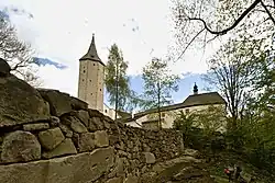
 Roštejn Castle | |
_Flag.jpg.webp) Flag _CoA.jpg.webp) Coat of arms | |
 Doupě Location in the Czech Republic | |
| Coordinates: 49°14′13″N 15°26′5″E / 49.23694°N 15.43472°E | |
| Country | |
| Region | Vysočina |
| District | Jihlava |
| First mentioned | 1580 |
| Area | |
| • Total | 5.12 km2 (1.98 sq mi) |
| Elevation | 593 m (1,946 ft) |
| Population (2023-01-01)[1] | |
| • Total | 101 |
| • Density | 20/km2 (51/sq mi) |
| Time zone | UTC+1 (CET) |
| • Summer (DST) | UTC+2 (CEST) |
| Postal code | 588 56 |
| Website | www |
Doupě (Czech pronunciation: [ˈdoupjɛ]) is a municipality and village in Jihlava District in the Vysočina Region of the Czech Republic. It has about 100 inhabitants.
Etymology
The name literally means 'den'. Figuratively, it refers to the enclosed valley in which the village is located.[2]
Geography
Doupě is located about 21 kilometres (13 mi) southwest of Jihlava. The southern part of the municipal territory with the village lies in the Křižanov Highlands, the northern forested part lies in the Javořice Highlands. The highest point is the hill Vyštěnec at 688 m (2,257 ft) above sea level. The territory is rich in ponds.
History
The first written mention of Doupě is from 1580.[2]
Sights
Doupě is known for the Roštejn Castle. The first written mention of the castle is from 1353. Today it is owned by the Vysočina Region and managed by the Vysočina Museum in Jihlava.[3] The castle is open to the public and belongs to the most visited tourist destinations in the region.[4]
References
- ↑ "Population of Municipalities – 1 January 2023". Czech Statistical Office. 2023-05-23.
- 1 2 "Historie" (in Czech). Obec Doupě. Retrieved 2023-01-26.
- ↑ "Historie a pověsti". Roštejn Castle (in Czech). Vysočina Museum in Jihlava. Retrieved 2023-01-26.
- ↑ "Turisté mají v České republice nejraději zoologické zahrady, technické památky, koupání a Pražský hrad" (in Czech). CzechTourism. 2022-06-24. Retrieved 2023-01-26.