Jihlávka | |
|---|---|
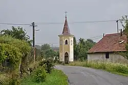 Belfry | |
 Flag  Coat of arms | |
 Jihlávka Location in the Czech Republic | |
| Coordinates: 49°15′40″N 15°17′33″E / 49.26111°N 15.29250°E | |
| Country | |
| Region | Vysočina |
| District | Jihlava |
| First mentioned | 1356 |
| Area | |
| • Total | 8.39 km2 (3.24 sq mi) |
| Elevation | 651 m (2,136 ft) |
| Population (2023-01-01)[1] | |
| • Total | 195 |
| • Density | 23/km2 (60/sq mi) |
| Time zone | UTC+1 (CET) |
| • Summer (DST) | UTC+2 (CEST) |
| Postal code | 588 51 |
| Website | obecjihlavka |
Jihlávka (Czech pronunciation: [ˈjɪɦlaːfka]; German: Klein Iglau) is a municipality and village in Jihlava District in the Vysočina Region of the Czech Republic. It has about 200 inhabitants.
Geography
Jihlávka is located about 26 kilometres (16 mi) southwest of Jihlava. It lies on the border between the Křemešník Highlands and Křižanov Highlands. The highest point is the Lísek hill at 760 m (2,490 ft) above sea level. The Jihlava River originates in the municipal territory. There are several ponds in the municipality; the largest of them is Bor.
References
External links
Wikimedia Commons has media related to Jihlávka.
This article is issued from Wikipedia. The text is licensed under Creative Commons - Attribution - Sharealike. Additional terms may apply for the media files.