Kapit | |
|---|---|
Division of Sarawak | |
 Seal | |
 | |
| Division Office location | Kapit |
| Government | |
| • Body | Majlis Daerah Kapit (MDK) |
| Area | |
| • Total | 38,934 km2 (15,033 sq mi) |
| Population (2020)[1] | |
| • Total | 134,800 |
| • Density | 3.5/km2 (9.0/sq mi) |
| Resident | Nyurak Keti |
| License plate prefix | QP |
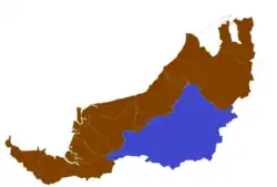
Kapit Division, formed on 2 April 1973, is one of the twelve administrative divisions in Sarawak, Malaysia. It has a total area of 38,934 square kilometres, and is the largest of the administrative divisions of Sarawak.
Its population (year 2020 census) was 134,800. Ethnically, the population of Kapit Division was 68% Iban, 19.1% Orang Ulu (Kenyah, Kayan, Penan etc.) , 7% Chinese, 3.4% Malay, 1.3% Melanau, and 0.3% Bidayuh, and 0.1% other.
Kapit Division consists of three districts (Kapit, Song and Belaga) and two sub-districts (Nanga Merit and Sungai Asap).
Some 86% of the land area is held in forest reserve. The economy is largely agricultural, based on forestry, oil palm, paddy, rubber, banana, and pepper. Other natural resources include coal. The Bakun Dam is based partly in Kapit Division.
Administration
Members of Parliament
| Parliament | Member of Parliament | Party |
|---|---|---|
| P215 Kapit | YB Datuk Alexander Nanta Linggi | GPS (PBB) |
| P216 Hulu Rajang | YB Datuk Wilson Ugak Kumbong | GPS (PRS) |
References
- ↑ "The Official Portal of the Sarawak Government". sarawak.gov.my. Retrieved 25 May 2022.
External links
| SCORE division | |
|---|---|
| SCORE cities and towns |
|
| SCORE hydroelectric dams | |
| SCORE infrastructure | |
1°57′07.2″N 112°56′35.1″E / 1.952000°N 112.943083°E