| Mount Allen | |
|---|---|
| Shappee | |
 | |
| Highest point | |
| Elevation | 3,310 m (10,860 ft)[1][2] |
| Prominence | 260 m (850 ft)[3][notes 1] |
| Listing | |
| Coordinates | 51°17′33″N 116°13′12″W / 51.29250°N 116.22000°W[4] |
| Geography | |
 Mount Allen Location in Alberta  Mount Allen Mount Allen (British Columbia) | |
| Country | Canada |
| Provinces | Alberta and British Columbia |
| Parks | Banff and Yoho |
| Parent range | Canadian Rockies |
| Topo map | NTS 82N8 Lake Louise[4] |
| Climbing | |
| First ascent | 1904 Gertrude Benham, Christian Kaufmann[1][3] |
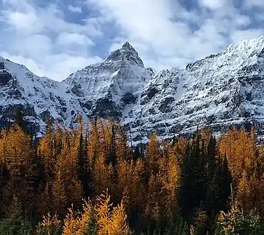
Mount Allen is a mountain in the Canadian Rockies, on the Continental Divide, which forms the provincial boundary between British Columbia and Alberta in this region. J. Monroe Thorington named this mountain for Samuel Evans Stokes Allen in 1924.[3][5] Allen was an American cartographer who mapped this area of the Rockies in 1894-95.[6][7][8] Allen had named this mountain "Shappee", the Stoney language word for "six", as part of his naming of the ten mountains in the Valley of the Ten Peaks.[8] The peak forms part of the backdrop to Moraine Lake in Banff National Park.
Geology
The mountains in Banff Park are composed of sedimentary rock laid down during the Precambrian to Jurassic periods.[9] Formed in shallow seas, this sedimentary rock was pushed east and over the top of younger rock during the Laramide orogeny.[10]
Climate
Based on the Köppen climate classification, the mountain has a subarctic climate with cold, snowy winters, and mild summers.[11] Temperatures can drop below −20 °C with wind chill factors below −30 °C in the winter.
See also
Gallery
 Allen from Larch Valley
.jpg.webp) Moraine Lake with Mount Allen centered
Moraine Lake with Mount Allen centered
References
- 1 2 "Mount Allen". cdnrockiesdatabases.ca. Retrieved 2019-08-14.
- ↑ Lake Louise & Yoho (Map). 1:50,000. Cochrane, AB: Gem Trek Publishing. 2001. § D4. ISBN 1-895526-15-9. Retrieved 2019-08-14.
- 1 2 3 "Mount Allen". Bivouac.com. Retrieved 2010-02-06.
- 1 2 "Mount Allen". Geographical Names Data Base. Natural Resources Canada. Retrieved 2019-08-14.
- ↑ "Mount Allen". BC Geographical Names. Retrieved 2023-09-12.
- ↑ Boles, Glen W.; Laurilla, Roger W.; Putnam, William L. (2006). Canadian Mountain Place Names. Vancouver: Rocky Mountain Books. ISBN 978-1-894765-79-4.
- ↑ "Samuel Evans Stokes Allen, 1874-1945". American Alpine Club. Retrieved 2019-05-08.
- 1 2 Sanford, Emerson; Beck, Janice Sanford (2010). Historic Hikes Around Mount Assiniboine & in Kananaskis Country. Rocky Mountain Books Ltd. p. 125. ISBN 9781897522806. Retrieved 2019-08-14.
- ↑ Belyea, Helen R. (1960). The Story of the Mountains in Banff National Park (PDF). parkscanadahistory.com (Report). Ottawa: Geological Survey of Canada. Archived (PDF) from the original on 2015-10-02. Retrieved 2019-09-13.
- ↑ Gadd, Ben (2008). Geology of the Rocky Mountains and Columbias.
- ↑ Peel, M. C.; Finlayson, B. L.; McMahon, T. A. (2007). "Updated world map of the Köppen−Geiger climate classification". Hydrol. Earth Syst. Sci. 11: 1633–1644. ISSN 1027-5606.
- Notes
- ↑ Prominence based on summit elevation of 3280 m.
Further reading
- Birrell, Dave (2000). 50 Roadside Panoramas in the Canadian Rockies. Rocky Mountain Books Ltd. p. 87. ISBN 9780921102656. Retrieved 2019-08-14.
External links
- Parks Canada web site: Banff National Park
- Mount Allen weather: Mountain Forecast
- Samuel E.S. Allen in memoriam: Americanalpineclub.org