Roucy | |
|---|---|
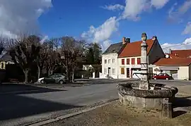 The square in Roucy | |
 Coat of arms | |
Location of Roucy | |
 Roucy  Roucy | |
| Coordinates: 49°22′22″N 3°48′57″E / 49.3728°N 3.8158°E | |
| Country | France |
| Region | Hauts-de-France |
| Department | Aisne |
| Arrondissement | Laon |
| Canton | Villeneuve-sur-Aisne |
| Intercommunality | Champagne Picarde |
| Government | |
| • Mayor (2020–2026) | Évelyne Bernard[1] |
| Area 1 | 6.96 km2 (2.69 sq mi) |
| Population | 384 |
| • Density | 55/km2 (140/sq mi) |
| Time zone | UTC+01:00 (CET) |
| • Summer (DST) | UTC+02:00 (CEST) |
| INSEE/Postal code | 02656 /02160 |
| Elevation | 55–206 m (180–676 ft) (avg. 100 m or 330 ft) |
| 1 French Land Register data, which excludes lakes, ponds, glaciers > 1 km2 (0.386 sq mi or 247 acres) and river estuaries. | |
Roucy (French pronunciation: [ʁusi]) is a small commune in the Aisne department in Hauts-de-France in northern France. Notable features of this town include the wide central plaza on which village fetes occur every summer.
Population
| Year | Pop. | ±% |
|---|---|---|
| 1962 | 253 | — |
| 1968 | 223 | −11.9% |
| 1975 | 249 | +11.7% |
| 1982 | 293 | +17.7% |
| 1990 | 281 | −4.1% |
| 1999 | 329 | +17.1% |
| 2008 | 404 | +22.8% |
| 2012 | 390 | −3.5% |
See also
References
- ↑ "Répertoire national des élus: les maires". data.gouv.fr, Plateforme ouverte des données publiques françaises (in French). 9 August 2021.
- ↑ "Populations légales 2021". The National Institute of Statistics and Economic Studies. 28 December 2023.
Wikimedia Commons has media related to Roucy.
This article is issued from Wikipedia. The text is licensed under Creative Commons - Attribution - Sharealike. Additional terms may apply for the media files.