Tunchang
屯昌县 | |
|---|---|
 | |
.png.webp) Location in Hainan | |
| Coordinates: 19°21′58″N 110°9′54″E / 19.36611°N 110.16500°E | |
| Country | People's Republic of China |
| Province | Hainan |
| Area | |
| • Total | 1,231.5 km2 (475.5 sq mi) |
| Population (1999) | |
| • Total | 250,059 |
| • Density | 200/km2 (530/sq mi) |
| Time zone | UTC+8 (China standard time) |
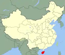
Tunchang County is a county of Hainan Province, People's Republic of China. Its postal code is 571600, and in 1999 its population was 250,059 people. The administrative seat lies at Tuncheng.
There are four main attractions in this county: The Muse Lake, The Standard Model Deer Farm, Shi Xia Hairui Ancestral Home and the Wolong Mountain.
In 1983, a company from Guangxi moved to Tunchang and started raising geoemydid turtles on a farm.[1] They have since moved to a place near Sanya, which is closer to the ocean.

Tunchang deer farm
Climate
| Climate data for Tunchang (1991–2020 normals, extremes 1981–2010) | |||||||||||||
|---|---|---|---|---|---|---|---|---|---|---|---|---|---|
| Month | Jan | Feb | Mar | Apr | May | Jun | Jul | Aug | Sep | Oct | Nov | Dec | Year |
| Record high °C (°F) | 33.5 (92.3) |
36.3 (97.3) |
36.8 (98.2) |
39.3 (102.7) |
39.1 (102.4) |
38.2 (100.8) |
39.5 (103.1) |
37.2 (99.0) |
36.8 (98.2) |
34.2 (93.6) |
34.1 (93.4) |
32.0 (89.6) |
39.5 (103.1) |
| Mean daily maximum °C (°F) | 22.6 (72.7) |
24.7 (76.5) |
28.1 (82.6) |
31.1 (88.0) |
33.2 (91.8) |
33.9 (93.0) |
33.6 (92.5) |
32.9 (91.2) |
31.4 (88.5) |
29.2 (84.6) |
26.5 (79.7) |
23.0 (73.4) |
29.2 (84.5) |
| Daily mean °C (°F) | 18.2 (64.8) |
19.9 (67.8) |
22.9 (73.2) |
25.8 (78.4) |
27.6 (81.7) |
28.6 (83.5) |
28.4 (83.1) |
27.7 (81.9) |
26.6 (79.9) |
24.8 (76.6) |
22.4 (72.3) |
19.1 (66.4) |
24.3 (75.8) |
| Mean daily minimum °C (°F) | 15.4 (59.7) |
16.9 (62.4) |
19.6 (67.3) |
22.4 (72.3) |
24.2 (75.6) |
25.3 (77.5) |
25.1 (77.2) |
24.6 (76.3) |
23.9 (75.0) |
22.1 (71.8) |
19.8 (67.6) |
16.6 (61.9) |
21.3 (70.4) |
| Record low °C (°F) | 4.8 (40.6) |
5.4 (41.7) |
5.9 (42.6) |
14.0 (57.2) |
15.5 (59.9) |
20.0 (68.0) |
21.3 (70.3) |
19.5 (67.1) |
18.3 (64.9) |
12.7 (54.9) |
9.3 (48.7) |
3.8 (38.8) |
3.8 (38.8) |
| Average precipitation mm (inches) | 30.1 (1.19) |
37.6 (1.48) |
44.5 (1.75) |
115.5 (4.55) |
263.3 (10.37) |
192.5 (7.58) |
220.6 (8.69) |
321.5 (12.66) |
354.7 (13.96) |
361.0 (14.21) |
108.1 (4.26) |
66.5 (2.62) |
2,115.9 (83.32) |
| Average precipitation days (≥ 0.1 mm) | 11.0 | 10.6 | 10.5 | 12.5 | 17.7 | 16.5 | 16.2 | 19.2 | 18.5 | 14.5 | 11.5 | 12.2 | 170.9 |
| Average relative humidity (%) | 86 | 84 | 81 | 80 | 80 | 78 | 79 | 83 | 85 | 84 | 84 | 84 | 82 |
| Mean monthly sunshine hours | 100.9 | 112.4 | 154.1 | 180.9 | 206.3 | 212.8 | 223.7 | 197.7 | 157.5 | 147.6 | 114.9 | 87.1 | 1,895.9 |
| Percent possible sunshine | 29 | 35 | 41 | 48 | 51 | 54 | 55 | 50 | 43 | 41 | 34 | 26 | 42 |
| Source: China Meteorological Administration[2][3] | |||||||||||||
See also
References
- ↑ "Archived copy" (PDF). Archived from the original (PDF) on 20 October 2004. Retrieved 4 May 2005.
{{cite web}}: CS1 maint: archived copy as title (link) , page 15. Their source, with details and photos, is: Shi, Haitao; Parham, James Ford (2000), "Preliminary Observations of a Large Turtle Farm in Hainan Province, People's Republic of China", Turtle and Tortoise Newsletter, 3: 4–6 - ↑ 中国气象数据网 – WeatherBk Data (in Simplified Chinese). China Meteorological Administration. Retrieved 17 June 2023.
- ↑ 中国气象数据网 (in Simplified Chinese). China Meteorological Administration. Retrieved 17 June 2023.
- Harvard University Committee on the Environment (1999). "China County & City Population 1999 FAQ". Archived from the original on 9 January 2016.
- Official website (Chinese)
External links
 Media related to Tunchang at Wikimedia Commons
19°21′58″N 110°09′54″E / 19.366°N 110.165°E
This article is issued from Wikipedia. The text is licensed under Creative Commons - Attribution - Sharealike. Additional terms may apply for the media files.
