Xinzhou
忻州市 | |
|---|---|
 | |
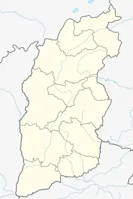
.png.webp) Location of Xinzhou City jurisdiction in Shanxi | |
 Xinzhou Location of the city centre in Shanxi | |
| Coordinates (Xinzhou Municipal Government): 38°24′58″N 112°44′02″E / 38.416°N 112.734°E | |
| Country | People's Republic of China |
| Province | Shanxi |
| County-level divisions | 14 |
| City seat | Xinfu |
| Government | |
| • Type | Prefecture-level city |
| • CPC Xinzhou Secretary | Li Junming (李俊明) |
| • Mayor | Zheng Liansheng (郑连生) |
| Area | |
| • Prefecture-level city | 25,180 km2 (9,720 sq mi) |
| • Urban | 183.00 km2 (70.66 sq mi) |
| • Districts[1] | 1,982.0 km2 (765.3 sq mi) |
| Population (2010)[2] | |
| • Prefecture-level city | 3,067,501 |
| • Density | 120/km2 (320/sq mi) |
| • Urban | 302,500 |
| • Urban density | 1,700/km2 (4,300/sq mi) |
| • Districts[1] | 578,000 |
| Time zone | UTC+08:00 (China Standard) |
| Postal code | 034000 |
| Area code | 0350 |
| ISO 3166 code | CN-SX-09 |
| Licence plates | 晋H |
| Administrative division code | 140900 |
| Website | www |
| Xinzhou | |||||||||
|---|---|---|---|---|---|---|---|---|---|
| Chinese | 忻州 | ||||||||
| |||||||||
Xinzhou, ancient name Xiurong (秀荣),[3] is a prefecture-level city occupying the north-central section of Shanxi Province in the People's Republic of China, bordering Hebei to the east, Shaanxi to the west, and Inner Mongolia to the northwest.
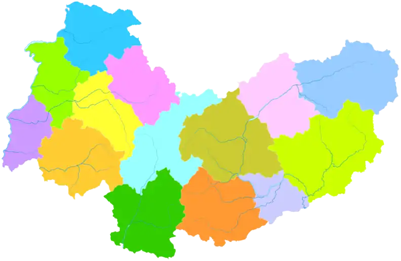
Administrative divisions

| Map | ||||||
|---|---|---|---|---|---|---|
| # | Name | Hanzi | Hanyu Pinyin | Population (2003 est.) | Area (km²) | Density (/km²) |
| 1 | Xinfu District | 忻府区 | Xīnfǔ Qū | 510,000 | 1,954 | 261 |
| 2 | Yuanping City | 原平市 | Yuánpíng Shì | 470,000 | 2,571 | 183 |
| 3 | Dingxiang County | 定襄县 | Dìngxiāng Xiàn | 210,000 | 864 | 243 |
| 4 | Wutai County | 五台县 | Wǔtái Xiàn | 310,000 | 2,968 | 104 |
| 5 | Dai County | 代县 | Dài Xiàn | 200,000 | 1,720 | 116 |
| 6 | Fanshi County | 繁峙县 | Fánshì Xiàn | 240,000 | 2,369 | 101 |
| 7 | Ningwu County | 宁武县 | Níngwǔ Xiàn | 160,000 | 1,966 | 81 |
| 8 | Jingle County | 静乐县 | Jìnglè Xiàn | 160,000 | 2,063 | 78 |
| 9 | Shenchi County | 神池县 | Shénchí Xiàn | 100,000 | 1,456 | 69 |
| 10 | Wuzhai County | 五寨县 | Wǔzhài Xiàn | 100,000 | 1,379 | 73 |
| 11 | Kelan County | 岢岚县 | Kělán Xiàn | 80,000 | 1,980 | 40 |
| 12 | Hequ County | 河曲县 | Héqǔ Xiàn | 140,000 | 1,327 | 106 |
| 13 | Baode County | 保德县 | Bǎodé Xiàn | 150,000 | 981 | 153 |
| 14 | Pianguan County | 偏关县 | Piānguān Xiàn | 110,000 | 1,682 | 65 |
Climate
Xinzhou has a continental, monsoon-influenced semi-arid climate (Köppen BSk),[4] with cold, very dry, and somewhat long winters, and warm, somewhat humid summers. The monthly 24-hour average temperature ranges from −9.1 °C (15.6 °F) in January to 22.8 °C (73.0 °F) in July, and the annual mean is 8.51 °C (47.3 °F). Typifying the influence of the East Asian Monsoon, close to three-fourths of the annual 428 millimetres (16.9 in) of precipitation occurs from June to September.
| Climate data for Xinzhou (Xinfu District, 1991–2020 normals, extremes 1981–2010) | |||||||||||||
|---|---|---|---|---|---|---|---|---|---|---|---|---|---|
| Month | Jan | Feb | Mar | Apr | May | Jun | Jul | Aug | Sep | Oct | Nov | Dec | Year |
| Record high °C (°F) | 13.4 (56.1) |
17.5 (63.5) |
26.9 (80.4) |
36.4 (97.5) |
37.6 (99.7) |
37.7 (99.9) |
37.9 (100.2) |
35.1 (95.2) |
34.5 (94.1) |
29.1 (84.4) |
21.8 (71.2) |
14.7 (58.5) |
37.9 (100.2) |
| Mean daily maximum °C (°F) | 0.3 (32.5) |
4.9 (40.8) |
12.0 (53.6) |
20.3 (68.5) |
26.2 (79.2) |
29.2 (84.6) |
29.3 (84.7) |
27.8 (82.0) |
23.6 (74.5) |
17.5 (63.5) |
8.4 (47.1) |
1.5 (34.7) |
16.8 (62.1) |
| Daily mean °C (°F) | −8.1 (17.4) |
−3.2 (26.2) |
4.3 (39.7) |
12.4 (54.3) |
18.6 (65.5) |
22.0 (71.6) |
23.1 (73.6) |
21.2 (70.2) |
16.0 (60.8) |
9.2 (48.6) |
1.0 (33.8) |
−6.2 (20.8) |
9.2 (48.5) |
| Mean daily minimum °C (°F) | −14.1 (6.6) |
−9.4 (15.1) |
−2.3 (27.9) |
4.7 (40.5) |
10.6 (51.1) |
14.9 (58.8) |
17.6 (63.7) |
16.0 (60.8) |
9.8 (49.6) |
2.9 (37.2) |
−4.5 (23.9) |
−11.7 (10.9) |
2.9 (37.2) |
| Record low °C (°F) | −29.2 (−20.6) |
−24.7 (−12.5) |
−17.5 (0.5) |
−8.1 (17.4) |
−2.2 (28.0) |
4.7 (40.5) |
7.9 (46.2) |
5.7 (42.3) |
−2.6 (27.3) |
−10.0 (14.0) |
−24.6 (−12.3) |
−30.0 (−22.0) |
−30.0 (−22.0) |
| Average precipitation mm (inches) | 2.4 (0.09) |
4.4 (0.17) |
10.5 (0.41) |
21.9 (0.86) |
33.7 (1.33) |
62.4 (2.46) |
111.8 (4.40) |
106.2 (4.18) |
58.4 (2.30) |
28.9 (1.14) |
12.4 (0.49) |
2.3 (0.09) |
455.3 (17.92) |
| Average precipitation days (≥ 0.1 mm) | 1.6 | 2.3 | 3.2 | 5.4 | 6.4 | 10.6 | 12.5 | 12.0 | 8.7 | 5.9 | 3.3 | 1.6 | 73.5 |
| Average snowy days | 2.0 | 2.9 | 2.2 | 0.9 | 0 | 0 | 0 | 0 | 0 | 0.2 | 2.0 | 2.1 | 12.3 |
| Average relative humidity (%) | 54 | 50 | 46 | 43 | 44 | 57 | 76 | 79 | 76 | 67 | 62 | 57 | 59 |
| Mean monthly sunshine hours | 160.7 | 170.7 | 211.3 | 234.7 | 258.5 | 230.9 | 211.9 | 204.8 | 192.6 | 193.3 | 165.6 | 163.6 | 2,398.6 |
| Percent possible sunshine | 53 | 56 | 57 | 59 | 58 | 52 | 48 | 49 | 52 | 57 | 55 | 56 | 54 |
| Source: China Meteorological Administration[5][6] | |||||||||||||
Demographics
According to the seventh national census of Xinzhou, the prefecture city had 2,689,700 inhabitants in 2020, of whom the built-up (or metro) area was home to 1,446,400 inhabitants. Contrasting to the previous census conducted in 2000, there is a decline of 378,000 inhabitants (-12.32%, or -1.31% annually). Xinzhou is the eighth populous city in Shanxi. The illiteracy rate of Xinzhou is 2.39%, a 1.13% decrease since 2010. Xinzhou’s sex ratio is 106:100 (Woman is 100).[7]
Tourism
Dai County is home to the AAAAA-rated Yanmen Pass, a mountain pass hosting a major fortification along the Great Wall. And Mount Wutai is one of four sacred mountain of Buddhist (中国佛教四圣山).[3]
Education
Xinzhou has numerous public high schools. And Xin Zhou Di Yi Zhong Xue (Xin Zhou Number One High School), is considered the most prestigious public high school in this region.
Another public high school of interest is the nearby laboratory high school. It functions as an extension of the Xin Zhou Normal University. The third famous high school is the Xin Zhou Shi Yan Zhong Xue (Xin Zhou Experimental High School). This school was initiated as a public-private partnership. The school is partially funded by the Chinese government, follows national educational standards, and maintains close ties (and even joint faculty) with Xin Zhou Yi Zhong Xue; however, it maintains a greater independence from the government than traditional public schools. The experimental school also runs a small primary school program (generally only one classroom per grade level) which is populated almost exclusively by the children of Yi Zhong Xue and Shi Yan Zhong Xue teachers.
Transportation
References
- 1 2 3 4 Ministry of Housing and Urban-Rural Development, ed. (2019). China Urban Construction Statistical Yearbook 2017. Beijing: China Statistics Press. p. 46. Retrieved 11 January 2020.
- ↑ 2010年忻州市第六次全国人口普查主要数据公报 [Sixth National Population Census of the People's Republic of China]. National Bureau of Statistics of China. Retrieved 30 August 2012.
- 1 2 "忻州市情". 忻州市人民政府. 2021-08-31. Retrieved 2022-06-28.
- ↑ Peel, M. C., Finlayson, B. L., and McMahon, T. A.: Updated world map of the Köppen-Geiger climate classification, Hydrol. Earth Syst. Sci., 11, 1633-1644, doi:10.5194/hess-11-1633-2007, 2007.
- ↑ 中国气象数据网 – WeatherBk Data (in Simplified Chinese). China Meteorological Administration. Retrieved 26 August 2023.
- ↑ 中国气象数据网 (in Simplified Chinese). China Meteorological Administration. Retrieved 26 August 2023.
- ↑ "第七次全国人口普查忻州市人口发展情况综述". 忻州市人民政府. 2021-08-03. Retrieved 2022-06-28.

