Březina | |
|---|---|
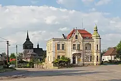
 Centre of Březina, church in the background | |
_Flag.jpg.webp) Flag _CoA.jpg.webp) Coat of arms | |
 Březina Location in the Czech Republic | |
| Coordinates: 50°32′55″N 15°1′58″E / 50.54861°N 15.03278°E | |
| Country | |
| Region | Central Bohemian |
| District | Mladá Boleslav |
| First mentioned | 1222 |
| Area | |
| • Total | 5.62 km2 (2.17 sq mi) |
| Elevation | 237 m (778 ft) |
| Population (2023-01-01)[1] | |
| • Total | 434 |
| • Density | 77/km2 (200/sq mi) |
| Time zone | UTC+1 (CET) |
| • Summer (DST) | UTC+2 (CEST) |
| Postal codes | 294 11, 295 01 |
| Website | www |
Březina is a municipality and village in Mladá Boleslav District in the Central Bohemian Region of the Czech Republic. It has about 400 inhabitants.
Administrative parts
The village of Honsob is an administrative part of Březina.
Geography
Březina is located about 16 km (10 mi) northeast of Mladá Boleslav and 23 km (14 mi) south of Liberec. It lies in the Jičín Uplands. The highest point is a contour line on the hill Mužský at 408 m (1,339 ft) above sea level. The Jizera River forms part of the municipal border in the north.
The eastern part of the municipal territory lies in the Bohemian Paradise Protected Landscape Area. In this area is located Žabakor Pond, the largest body of water in Bohemian Paradise with an area of 45 ha (110 acres). It was founded for fish farming in the 16th century and today it is an important nesting site for water birds, protected as a nature reserve.[2]
History
The first written mention of Březina is from 1222.[3]
Transport
The D10 motorway from Prague to Turnov passes through the municipality.
Sights
The landmark of Březina is the Church of Saint Lawrence. It was built at the turn of the 13th and 14th centuries and rebuilt in the Renaissance style in the 16th century. It is a stone church with a wooden tower floor.[3]
References
- ↑ "Population of Municipalities – 1 January 2023". Czech Statistical Office. 2023-05-23.
- ↑ "Rybník Žabakor s ptačí pozorovatelnou" (in Czech). CzechTourism. Retrieved 2023-02-23.
- 1 2 "Historie obce" (in Czech). Obec Březina. Retrieved 2023-02-23.