Hrdlořezy | |
|---|---|
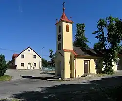 Chapel of Saint John of Nepomuk | |
_vlajka.jpg.webp) Flag _znak.jpg.webp) Coat of arms | |
 Hrdlořezy Location in the Czech Republic | |
| Coordinates: 50°27′5″N 14°52′32″E / 50.45139°N 14.87556°E | |
| Country | |
| Region | Central Bohemian |
| District | Mladá Boleslav |
| First mentioned | 1406 |
| Area | |
| • Total | 9.68 km2 (3.74 sq mi) |
| Elevation | 286 m (938 ft) |
| Population (2022-01-01)[1] | |
| • Total | 762 |
| • Density | 79/km2 (200/sq mi) |
| Time zone | UTC+1 (CET) |
| • Summer (DST) | UTC+2 (CEST) |
| Postal code | 293 07 |
| Website | www |
Hrdlořezy is a municipality and village in Mladá Boleslav District in the Central Bohemian Region of the Czech Republic. It has about 800 inhabitants.
Geography
Hrdlořezy is located about 3 km (2 mi) northwest of Mladá Boleslav and 46 km (29 mi) northeast of Prague. It lies in the Jizera Table. The municipality is situated on the right bank of the Jizera River.
History
The first written mention of Hrdlořezy is from 1406. It was a typical agricultural village.[2]
Sights
The landmark of Hrdlořezy is the Chapel of Saint John of Nepomuk in the centre of the village.[2]
Gallery
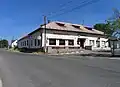 Restaurant at Hrdlořezy
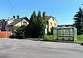 Upper common
References
- ↑ "Population of Municipalities – 1 January 2022". Czech Statistical Office. 2022-04-29.
- 1 2 "Historie" (in Czech). Obec Hrdlořezy. Retrieved 2022-11-23.
External links
Wikimedia Commons has media related to Hrdlořezy (Mladá Boleslav District).
This article is issued from Wikipedia. The text is licensed under Creative Commons - Attribution - Sharealike. Additional terms may apply for the media files.