Bradlec | |
|---|---|
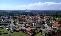
 View of Bradlec | |
 Flag  Coat of arms | |
 Bradlec Location in the Czech Republic | |
| Coordinates: 50°27′5″N 15°54′37″E / 50.45139°N 15.91028°E | |
| Country | |
| Region | Central Bohemian |
| District | Mladá Boleslav |
| First mentioned | 1382 |
| Area | |
| • Total | 2.63 km2 (1.02 sq mi) |
| Elevation | 293 m (961 ft) |
| Population (2023-01-01)[1] | |
| • Total | 1,386 |
| • Density | 530/km2 (1,400/sq mi) |
| Time zone | UTC+1 (CET) |
| • Summer (DST) | UTC+2 (CEST) |
| Postal code | 293 06 |
| Website | www |
Bradlec is a municipality and village in Mladá Boleslav District in the Central Bohemian Region of the Czech Republic. It has about 1,400 inhabitants.
Etymology
The name is derived from bradlo, meaning "rocky formation".[2]
Geography
Bradlec is located about 3 kilometres (2 mi) north of Mladá Boleslav and 48 km (30 mi) northeast of Prague. It lies mostly in the Jičín Uplands, only a small parts of the municipal territory extend into the Jizera Table. The highest point is at 309 m (1,014 ft) above sea level.
The municipality is located on an elevation of volcanic origin above the Jizera river valley. There are two small flooded quarries in the centre of Bradlec.[2]
History
The first written mention of Bradlec is from 1382. The village was founded by Knights Hospitaller around 1250.[3]
Sights
Bradlec is poor in monuments. There are only a small chapel and a wayside cross.[3]
References
- ↑ "Population of Municipalities – 1 January 2023". Czech Statistical Office. 2023-05-23.
- 1 2 "O obci" (in Czech). Obec Bradlec. Retrieved 2023-01-24.
- 1 2 "Bradlec" (in Czech). Město Bakov nad Jizerou. Retrieved 2023-01-24.