Josefův Důl | |
|---|---|
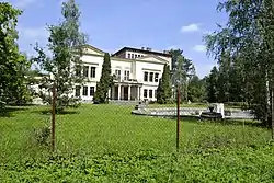
 Josefův Důl Castle | |
 Flag  Coat of arms | |
 Josefův Důl Location in the Czech Republic | |
| Coordinates: 50°27′12″N 14°53′38″E / 50.45333°N 14.89389°E | |
| Country | |
| Region | Central Bohemian |
| District | Mladá Boleslav |
| Founded | 1764 |
| Area | |
| • Total | 0.66 km2 (0.25 sq mi) |
| Elevation | 215 m (705 ft) |
| Population (2023-01-01)[1] | |
| • Total | 415 |
| • Density | 630/km2 (1,600/sq mi) |
| Time zone | UTC+1 (CET) |
| • Summer (DST) | UTC+2 (CEST) |
| Postal code | 293 07 |
| Website | www |
Josefův Důl is a municipality and village in Mladá Boleslav District in the Central Bohemian Region of the Czech Republic. It has about 400 inhabitants.
Geography
Písková Lhota is located about 3 km (2 mi) north of Mladá Boleslav and 47 km (29 mi) northeast of Prague. With an area of 0.66 km2 (0.25 sq mi), it belongs to the smallest municipalities in the country.[2] It lies in the Jizera Table. The municipality is situated on the left bank of the Jizera River, in a meander, which forms the northern and western municipal border.
History
The area originally belonged to Kosmonosy and in 1760, it was bought by Countess Marie Johana Bolza-Martinic. Josefův Důl was founded as a workers' colony in 1764, when a dyehouse was established here by Count Josef Bolza and its employees settled in its vicinity. The name Josefův Důl first appeared in 1790.[3][4]
Sights
The most valuable building in Josefův Důl is the so-called Josefův Důl Castle. It is a Neorenaissance villa built after 1860 for the then owner of the local factory, Friedrich von Leitenberger.[4]
References
- ↑ "Population of Municipalities – 1 January 2023". Czech Statistical Office. 2023-05-23.
- ↑ "Nejmenší obce České republiky – podle rozlohy" (in Czech). Skompasem.cz. 2019-01-14. Retrieved 2022-11-23.
- ↑ "Historie" (in Czech). Obec Josefův Důl. Retrieved 2022-11-23.
- 1 2 "Zámek" (in Czech). National Heritage Institute. Retrieved 2022-11-23.