Batňovice | |
|---|---|
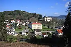 School and Church of Saint Bartholomew | |
 Flag  Coat of arms | |
 Batňovice Location in the Czech Republic | |
| Coordinates: 50°31′3″N 16°2′12″E / 50.51750°N 16.03667°E | |
| Country | |
| Region | Hradec Králové |
| District | Trutnov |
| First mentioned | 1408 |
| Area | |
| • Total | 4.47 km2 (1.73 sq mi) |
| Elevation | 364 m (1,194 ft) |
| Population (2023-01-01)[1] | |
| • Total | 772 |
| • Density | 170/km2 (450/sq mi) |
| Time zone | UTC+1 (CET) |
| • Summer (DST) | UTC+2 (CEST) |
| Postal code | 542 37 |
| Website | www |
Batňovice is a municipality and village in Trutnov District in the Hradec Králové Region of the Czech Republic. It has about 800 inhabitants.
History
The first written mention of Batňovice is from 1408.[2]
References
- ↑ "Population of Municipalities – 1 January 2023". Czech Statistical Office. 2023-05-23.
- ↑ "1009 – 1848 /Od středověku po absolutismus" (in Czech). Obec Batňovice. Retrieved 2022-10-28.
External links
Wikimedia Commons has media related to Batňovice.
This article is issued from Wikipedia. The text is licensed under Creative Commons - Attribution - Sharealike. Additional terms may apply for the media files.