Dolní Dvůr | |
|---|---|
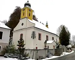
 Church of Saint Joseph | |
 Flag  Coat of arms | |
 Dolní Dvůr Location in the Czech Republic | |
| Coordinates: 50°39′8″N 15°39′20″E / 50.65222°N 15.65556°E | |
| Country | |
| Region | Hradec Králové |
| District | Trutnov |
| First mentioned | 1539 |
| Area | |
| • Total | 15.29 km2 (5.90 sq mi) |
| Elevation | 641 m (2,103 ft) |
| Population (2023-01-01)[1] | |
| • Total | 280 |
| • Density | 18/km2 (47/sq mi) |
| Time zone | UTC+1 (CET) |
| • Summer (DST) | UTC+2 (CEST) |
| Postal code | 543 42 |
| Website | www |
Dolní Dvůr (German: Niederhof) is a municipality and village in Trutnov District in the Hradec Králové Region of the Czech Republic. It has about 300 inhabitants.
History
The first written mention of Dolní Dvůr is from 1539.[2] In 1601, the village was separated from Lánov and the municipality was founded.[3]
Sights
The landmark of Dolníá Dvůr is the Church of Saint Joseph. It was built in the Neoclassical style in 1802–1806. It is equipped by a unique carillon.[4]
References
- ↑ "Population of Municipalities – 1 January 2023". Czech Statistical Office. 2023-05-23.
- ↑ "Dolní Dvůr" (in Czech). Hradec Králové Region. Retrieved 2022-10-12.
- ↑ "Průvodce historií" (in Czech). Obec Dolní Dvůr. Retrieved 2022-10-12.
- ↑ "Kostel sv. Josefa, Dolní Dvůr" (in Czech). Hradec Králové Region. Retrieved 2022-10-12.
Wikimedia Commons has media related to Dolní Dvůr.
This article is issued from Wikipedia. The text is licensed under Creative Commons - Attribution - Sharealike. Additional terms may apply for the media files.