Doubravice | |
|---|---|
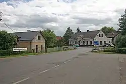 Crossroads in the centre of Doubravice | |
 Flag  Coat of arms | |
 Doubravice Location in the Czech Republic | |
| Coordinates: 50°24′20″N 15°45′43″E / 50.40556°N 15.76194°E | |
| Country | |
| Region | Hradec Králové |
| District | Trutnov |
| First mentioned | 1542 |
| Area | |
| • Total | 5.66 km2 (2.19 sq mi) |
| Elevation | 387 m (1,270 ft) |
| Population (2023-01-01)[1] | |
| • Total | 387 |
| • Density | 68/km2 (180/sq mi) |
| Time zone | UTC+1 (CET) |
| • Summer (DST) | UTC+2 (CEST) |
| Postal codes | 544 01, 544 51 |
| Website | www |
Doubravice is a municipality and village in Trutnov District in the Hradec Králové Region of the Czech Republic. It has about 400 inhabitants.
Administrative parts
Villages of Velehrádek and Zálesí are administrative parts of Doubravice.
References
Wikimedia Commons has media related to Doubravice (Trutnov District).
This article is issued from Wikipedia. The text is licensed under Creative Commons - Attribution - Sharealike. Additional terms may apply for the media files.