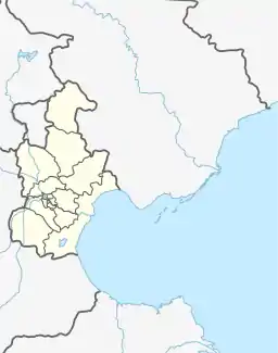
Cuihuangkou Town
崔黄口镇 | |
|---|---|
 Cuihuangkou Town  Cuihuangkou Town | |
| Coordinates: 39°31′56″N 117°11′30″E / 39.53222°N 117.19167°E | |
| Country | |
| Municipality | Tianjin |
| District | Wuqing |
| Village-level Divisions | 2 communities 49 villages |
| Area | |
| • Total | 90.97 km2 (35.12 sq mi) |
| Elevation | 6 m (20 ft) |
| Population (2010) | |
| • Total | 51,541 |
| • Density | 570/km2 (1,500/sq mi) |
| Time zone | UTC+8 (CST) |
| Postal code | 301702 |
| Area code | 022 |
Cuihuangkou Town (simplified Chinese: 崔黄口镇; traditional Chinese: 崔黃口鎮; pinyin: Cuīhuángkǒu Zhèn) is a town located on the northeastern part of Wuqing District, Tianjin, China. It borders Hebeitun and Dakoutun Towns in its north, Niujiapai and Dahuangbu Towns in its east, Caozili and Dajianchang Towns in its south, as well as Nancaicun and Daliang Towns in its west. It also has an exclave of Dahuangbu Town in its southeast. In 2010, the population of the town is 51,541.[1]
The area was originally named Quhuangkou (Chinese: 渠荒口; lit. 'Drainage Barren Mouth'), and was corrupted to Cuihuangkou by the influx of Khitan migrants during the Liao dynasty.[2]
Geography
Cuihuangkou Town is located on the southwest of the Qinglongwan River. The National Highway 233 passes through the eastern part of the town. Its average elevation is 6 meters above the sea level.[3]
History
| Years | Status | Under |
|---|---|---|
| 1934 - 1949 | Administered by 4th District | Wuqing County, Hebei |
| 1949 - 1950 | Administered by 2nd District | |
| 1950 - 1952 | Administered by 13th District | |
| 1952 - 1958 | Administered by 5th District | |
| 1958 - 1961 | Administered by Kuang'ergangbei People's Commune | |
| 1961 - 1973 | Cuihuangkou People's Commune Houxiang People's Commune | |
| 1973 - 1983 | Wuqing County, Tianjin | |
| 1983 - 1988 | Cuihuangkou Township Houxiang Township | |
| 1988 - 2000 | Cuihuangkou Town Houxiang Town | |
| 2000 - 2001 | Wuqing District, Tianjin | |
| 2001 - present | Cuihuangkou Town |
Administrative divisions
At the end of 2022, Cuihuangkou Town is formed from 51 subdivisions, including 2 residential communities and 49 villages. They are listed below:[4]
Residential communities
- Fuxiang Jiayuan (福巷嘉苑)
- Hongfu (鸿福)
Villages
- Yijie (一街)
- Sanjie (三街)
- Beizhuangzi (白庄子)
- Sijie (四街)
- Erjie (二街)
- Qianying (前营)
- Xigaokeng (西高坑)
- Gongxiaozhuang (龚小庄)
- Xingyao (邢窑)
- Gongying (龚营)
- Donggaokeng (东高坑)
- Dacaozhuang (大曹庄)
- Beixinzhuang (北辛庄)
- Chenxiangzhuang (陈相庄)
- Caodi (草地)
- Zhouxinzhuang (周辛庄)
- Dongzhaozhuang (东赵庄)
- Xiujiazhuang (修家庄)
- Huangliuzhuang (幌刘庄)
- Qianzhaozhuang (前赵庄)
- Tuonisi (坨泥寺)
- Dazhouzhuang (大周庄)
- Dongliangwo (东粮窝)
- Zao'anying (早安营)
- Wu'anying (五安营)
- Kangliuzhuang (康刘庄)
- Sulou (苏楼)
- Yuzhuangzi (于庄子)
- Nansancun (南三村)
- Beisancun (北三村委会)
- Xinzhuangsi (辛庄寺)
- Zhongsancun (中三村)
- Dianzicun (店子村)
- Xilücun (西吕村)
- Donglücun (东吕村)
- Nanxianhao (南县豪)
- Beixianhao (北县豪)
- Xidaliu (西大刘)
- Lixinzhuang (李辛庄)
- Dagongcheng Xicun (大宫城西村)
- Dagongcheng Dongcun (大宫城东村)
- Wangduzhuang (王杜庄)
- Xiaogongcheng (小宫城)
- Xicaozhuang (西曹庄)
- Zhoujiawu (周家务)
- Shenjiazhuang (沈家庄)
- Huaijiazhuang (槐家庄)
- Beijinzhuang (北靳庄)
- Dagongcheng Nancun (大宫城南村)
See also
References
- ↑ "China: Tiānjīn Municipal Province (Districts and Townships) - Population Statistics, Charts and Map". www.citypopulation.de. Retrieved 2023-06-01.
- 1 2 中华人民共和国政区大典 天津卷 [Collection of Administrative Divisions of the People's Republic of China, Tianjin Volumn] (in Chinese) (Di 1 ban ed.). 2020. ISBN 978-7-5087-6215-9. OCLC 1351675957.
- ↑ "Cuihuangkou topographic map, elevation, terrain". Topographic maps. Retrieved 2023-06-01.
- ↑ "2022年统计用区划代码和城乡划分代码" [2022 Statistical Division Codes and Urban-rural Differentiation Codes]. www.stats.gov.cn (in Chinese). Archived from the original on 2023-03-21. Retrieved 2023-06-01.