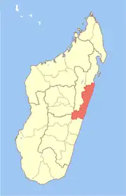
Maintinandry | |
|---|---|
 Maintinandry Location in Madagascar | |
| Coordinates: 19°25′48″S 48°55′51″E / 19.43000°S 48.93083°E | |
| Country | |
| Region | Atsinanana |
| District | Vatomandry District |
| Population (2001) | |
| • Total | 7,117[1] |
| Time zone | UTC3 (EAT) |
| Postal code | 517 |
Maintinandry [vatʷˈmanɖʐʲ] is a small village and commune in the Vatomandry District, Atsinanana Region, Madagascar.[2]
It is located near the coast, along the path of the Canal des Pangalanes, near the mouth of the Sakanila River, and about eight kilometres south of the village of Vatomandry. It is on Route Nationale (RN) 11, though as of 2006 that road is only improved through Vatomandry and the section leading to Maintinandry was described as a "potholed mud track."[2]
References
- ↑ 2001 Ilo Census Data, Cornell University
- 1 2 (29 March 2006). MADAGASCAR: Maintaining the roads to prosperity, IRIN
This article is issued from Wikipedia. The text is licensed under Creative Commons - Attribution - Sharealike. Additional terms may apply for the media files.
