Vatomandry (district) | |
|---|---|
 Vatomandry (district) Location in Madagascar | |
| Coordinates: 19°19′51″S 48°58′41″E / 19.33083°S 48.97806°E | |
| Country | |
| Region | Atsinanana |
| District | Vatomandry (district) |
| Population (2019)3ieme recensement | |
| • Total | 169,861 |
| Time zone | UTC+3 (EAT) |
Vatomandry is a district located in Atsinanana Region, Madagascar.
Etymology and location
Located on the coast, the town's name means 'Sleeping Rocks', derived from two black rocks near the shore. It is also on the path of the Canal des Pangalanes and Route Nationale (RN) 11.
History
In the pre-colonial era of the 19th century, Vatomandry was a center of Hova government with an active port.
Cyclone Manou caused great damage in 2003 to the town and left 68 people dead. Cyclone Giovanna in 2012 also caused significant damage.[1]
Religion
- Roman Catholic Apostolic Prefecture of Vatomandry[2]
Notable personalities
- Didier Ratsiraka (1936-2021), former President of Madagascar
Communes
The district is further divided into 15 communes:
References
- ↑ Quick response to Cyclone Giovanna had 20,000 children back in the classroom in Madagascar, Unicef.org, Retrieved 5 March 2013)
- ↑ http://www.gcathuntil 1olic.org/dioceses/diocese/toam0.htm
Capital: Toamasina | ||
| Antanambao Manampotsy - 507 | 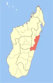 | |
| Mahanoro - 510 | ||
| Marolambo - 513 | ||
| Toamasina I - 501 | ||
| Toamasina II - 502 | ||
| Vatomandry - 517 | ||
| Vohabinany (Brickaville) - 508 | ||
7 districts; 75 communes | ||
This article is issued from Wikipedia. The text is licensed under Creative Commons - Attribution - Sharealike. Additional terms may apply for the media files.