The Oregon Portal

Oregon
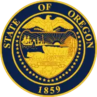
State of Oregon
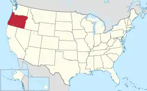
Map of the United States with Oregon highlighted

Oregon (/ˈɒrɪɡən/ ) is a state in the Pacific Northwest region of the United States. Oregon is a part of the Western United States, with the Columbia River delineating much of Oregon's northern boundary with Washington, while the Snake River delineates much of its eastern boundary with Idaho. The 42° north parallel delineates the southern boundary with California and Nevada. The western boundary is formed by the Pacific Ocean.

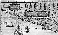
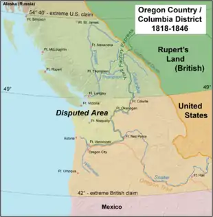
Oregon has been home to many indigenous nations for thousands of years. The first European traders, explorers, and settlers began exploring what is now Oregon's Pacific coast in the early to mid-16th century. As early as 1564, the Spanish began sending vessels northeast from the Philippines, riding the Kuroshio Current in a sweeping circular route across the northern part of the Pacific. In 1592, Juan de Fuca undertook detailed mapping and studies of ocean currents in the Pacific Northwest, including the Oregon coast as well as the strait now bearing his name. The Lewis and Clark Expedition traversed Oregon in the early 1800s, and the first permanent European settlements in Oregon were established by fur trappers and traders. In 1843, an autonomous government was formed in the Oregon Country, and the Oregon Territory was created in 1848. Oregon became the 33rd state of the U.S. on February 14, 1859.

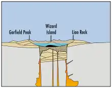
Today, with 4.2 million people over 98,000 square miles (250,000 km2), Oregon is the ninth largest and 27th most populous U.S. state. The capital, Salem, is the third-most populous city in Oregon, with 175,535 residents. Portland, with 652,503, ranks as the 26th among U.S. cities. The Portland metropolitan area, which includes neighboring counties in Washington, is the 25th largest metro area in the nation, with a population of 2,512,859. Oregon is also one of the most geographically diverse states in the U.S., marked by volcanoes, abundant bodies of water, dense evergreen and mixed forests, as well as high deserts and semi-arid shrublands. At 11,249 feet (3,429 m), Mount Hood is the state's highest point. Oregon's only national park, Crater Lake National Park, comprises the caldera surrounding Crater Lake, the deepest lake in the United States. The state is also home to the single largest organism in the world, Armillaria ostoyae, a fungus that runs beneath 2,200 acres (8.9 km2) of the Malheur National Forest. (Full article...)

Selected article -

Oregon State Capitol, view from Capitol Mall
The Oregon State Capitol is the building housing the state legislature and the offices of the governor, secretary of state, and treasurer of Oregon. It is located in the state capital, Salem. The current building, constructed in 1935 and expanded in 1977, is the third to house the Oregon state government since the state administration moved to Salem in 1852. Two former capitol buildings were destroyed by fire, one in 1855 and the other in 1935. New York architects Trowbridge & Livingston conceived the current structure's Art Deco design, in association with Francis Keally. Much of the interior and exterior are made of marble. The Oregon State Capitol was placed on the National Register of Historic Places in 1988. The Public Works Administration, part of the U.S. government, partially financed construction, which was completed during the Great Depression, in 1937. The building was erected at a cost of $2.5 million for the central portion of the building, which includes a dome of 166 feet (51 m).

Selected biography -

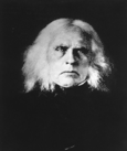
Doctor John McLoughlin
Dr. John McLoughlin (October 19, 1784 September 3, 1857) was the Chief Factor of the Columbia Fur District of the Hudson's Bay Company at Fort Vancouver. In 1798, he began 4½ years of medical training and was granted a license to practice medicine in 1803. He was hired as a physician at Fort William, Ontario (now Thunder Bay, Ontario), a fur-gathering post of the North West Company on Lake Superior. In 1814, he became a partner in the company, and in 1816 he was arrested for the murder of Robert Semple, the governor of the Red River Colony, after the Battle of Seven Oaks (1816). McLoughlin was tried on October 30, 1818, and the charges were dismissed. McLoughlin was instrumental in the negotiations leading to the North West Company's 1821 merger with the Hudson's Bay Company (HBC), and became Chief Factor of the Columbia District in 1824. McLoughlin was involved with the debate over the future of the Oregon Country. After retiring from the Hudson's Bay Company in 1846, McLoughlin moved his family back south to Oregon City in the Willamette Valley. In 1847, McLoughlin was given the Knighthood of St. Gregory, bestowed on him by Pope Gregory XVI. He became a U.S. citizen in 1849. He served as mayor of Oregon City in 1851, and died of natural causes in 1857. His grave is on a bluff above Willamette Falls. In 1953, the state of Oregon donated a statue of McLoughlin to the U.S. Capitol's National Statuary Hall Collection. The title "Father of Oregon" was officially bestowed on him by the Oregon Legislative Assembly in 1957.

In this month

<< Previous month Next month >>

More did you know -

Umpqua Bank Plaza

Did you know (auto-generated) -

General images -

The following are images from various Oregon-related articles on Wikipedia.

Selected image -
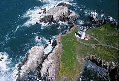
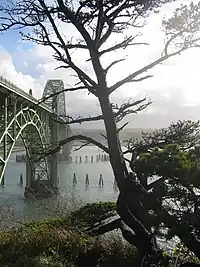
Yaquina Head Light
Yaquina Head Light

The Yaquina Head Light, also known early in its existence as the Cape Foulweather Lighthouse, is a lighthouse on the Oregon Coast. It is located in Lincoln County, near the mouth of the Yaquina River near Newport at Yaquina Head. Built from 1871 to 1873, it was automated in 1966 and is currently an active aid to navigation.

Selected quote -

Selected panorama -

Snake River near Oxbow, Oregon
The Snake River is a major tributary of the Columbia River in the U.S. states of Wyoming, Idaho, Oregon, and Washington. The river's length is 1,040 miles (1,674 km), its watershed drains 108,000 square miles (280,000 km2), and the average discharge at its mouth is 56,900 cubic feet per second (1,610 m³/s). The river flows from its source in Yellowstone National Park through a series of mountain ranges, canyons, and plains.

Main topics

Extended content
See also: Good articles relating to Oregon

Good articles

Picture of the day pictures

  • Interstate 82

Subcategories

Category puzzle
Category puzzle
Select [►] to view subcategories
Oregon
Oregon-related lists
Communications in Oregon
Oregon culture
Economy of Oregon
Education in Oregon
Environment of Oregon
Geography of Oregon
Government of Oregon
Health in Oregon
History of Oregon
Oregon law
Military in Oregon
Native American tribes in Oregon
Oregon's Most Endangered Places
People from Oregon
Politics of Oregon
Professional wrestling in Oregon
Science and technology in Oregon
Oregon society
Sports in Oregon
Transportation in Oregon
Works about Oregon
Images of Oregon
Oregon stubs

List articles

State facts

State symbols:

American beaver
Western meadowlark
Chinook salmon
Oregon grape
Oregon Swallowtail butterfly
Douglas fir
Metasequoia
Sunstone
Thunderegg

WikiProjects

WikiProjects
  • Oregon
    • Oregon State Highways
  • United States
    • U.S. states
    • United States regions

What are WikiProjects?

Things you can do

Extended content
This month's Collaboration of the Month projects: Women's History Month: Create or improve articles for women listed at Oregon Women of Achievement (modern) or Women of the West, Oregon chapter (historical)
Also, see this list of common redlinks, list of articles with cleanup tags, and list of articles needing immediate attention
  • Current Featured Article (or other Featured content) candidates:
  • Undergoing Peer review:
  • To Improve to Featured Standard: Oregon
  • Current Good Article Nominees:
  • To Improve and Nominate at WP:GOOD:
  • To Expand: History of Oregon, Government of Oregon
  • To Clean Up: WikiProject Oregon Cleanup listing
  • Review Recent Changes: See WikiProject Oregon recent changes list
  • To Merge: See Wikipedia:WikiProject Deletion sorting/Oregon#Merge proposals
  • To Split:
  • To Destub:
  • To Deorphan:
  • To Create: Geography of Oregon (currently a redir), High priority list, Portland Business Alliance, John Kitzhaber resignation, Women's Protective Division (formerly Women's Auxiliary to the Police Department for the Protection of Girls), Earle M. Chiles
  • To Create from Redirects: See Category:Redirect-Class Oregon articles (use caution)
  • To De-Redlink:
  • Lists to De-Redlink:
  • Lists to Complete:
  • Wanted Pics/Graphics: Requested photos
  • To add coordinates to articles in Category:Oregon articles missing geocoordinate data
  • Wanted New Pics:

Associated Wikimedia

The following Wikimedia Foundation sister projects provide more on this subject:

More portals

Discover Wikipedia using portals

44°00′N 120°30′W / 44°N 120.5°W / 44; -120.5

This article is issued from Wikipedia. The text is licensed under Creative Commons - Attribution - Sharealike. Additional terms may apply for the media files.