Shahr-e Kord
Persian: شهركرد Ancient names: Dezh Gord, Deh Kord | |
|---|---|
City | |
.jpg.webp) Panoramic view of Shahr-e Kord in 2013 | |
| Nickname(s): The City of Kindness, Bam-e Iran (Roof of Iran) | |
 Shahr-e Kord | |
| Coordinates: 32°19′52″N 50°51′34″E / 32.33111°N 50.85944°E[1] | |
| Country | |
| Province | Chaharmahal and Bakhtiari |
| County | Shahrekord |
| District | Central |
| Elevation | 2,070 m (6,790 ft) |
| Population (2016)[2] | |
| • Total | 190,441 |
| Time zone | UTC+3:30 (IRST) |
Shahr-e Kord (Persian: شهركرد, also Romanized as Shahrekord and Shahr Kord[3]) is a city in the Central District of Shahrekord County, Chaharmahal and Bakhtiari province, Iran, and serves as the capital of the province, county, and district.[4] It is the largest city in the province, and is 90 km away from Iran's third largest city, Isfahan. Shahr-e Kord is populated by Persians, Lurs and Turkic people.[5][6]
At the 2006 census, its population was 126,746 in 31,977 households.[7] The following census in 2011 counted 159,775 people in 44,081 households.[8] The latest census in 2016 showed the population had risen to 190,441 people in 55,492 households.[2]
Etymology
Shahr-e Kord, at face value, seems to mean "City of the Kurds". In antiquity, the place had been called "Dezh Gord" (دژگرد), where dezh (دژ) means "fortress" and gord (گرد) means "hero". After the Muslim conquest of Persia, the name changed to "Deh Kord" (Persian: دهكرد); dezh was reinterpreted as deh (ده) meaning "village" and gord became kord because the Arabic alphabet lacks the letters "g" (گ), and "zh" (ژ).[9] Other examples of cities whose names changed partly due to the influence of the Arabic language are Chamgordan, Boroujerd and Dezful, which were called Chamgord, Borougord and Dezhpol, respectively, before the Islamic conquest. In 1935, the name was finally changed to its present form with deh being replaced with shahr (شهر) meaning "city", which better reflects the size of Shahr-e Kord. On the other side, Lurs have been known as Kurds in the post Islamic conquest literature. Michael M. Gunter states that Lurs are closely related to the Kurds but that they "apparently began to be distinguished from the Kurds 1,000 years ago."[10]
History
Coins have been found in Shahr-e Kord dating back to the Sassanian and Parthian era.[11]
Notable people from Shahr-e Kord include painter Arghavan Khosravi.[12]
Language
The linguistic composition of the city:[13]
Geography
Shahr-e Kord (Zagros) is located about 90 km (56 mi) southwest of Isfahan and 512 km (318 mi) of Tehran. It is topographically situated in the north of the Zagros Mountains. Being located 2,070 m (6,790 ft) above the sea level, Shahr-e Kord (Zagros) is the most elevated among the centers of the provinces of Iran, known as the Roof of Iran.
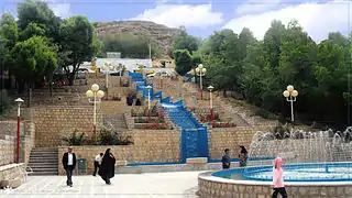 Mellat Park, Shahr-e Kord
 Bazaar Intersection, core of the City
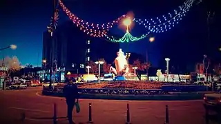 Abi Square
 Ferdowsi Square
 Imam Hossein Square
 Bostane Madar

Climate
Shahr-e Kord (Zagros) has a hot-summer mediterranean continental climate (Köppen: Dsa, Trewartha: Dc), with hot summer days, cool summer nights, very cold winter days and freezing winter nights. The annual average temperature in Shahr-e Kord (Zagros) is about 11 °C but the minimum and maximum absolute temperatures recorded in Shahr-e Kord (Zagros) during the last 30 years have been -32 °C and 42 °C, respectively. January is the coldest month and July is the hottest month. Although the humidity level is moderate or high in winter, the amount of rainfall is close to zero in planting seasons, except for April and May.
| Climate data for Shahre Kord (1955-2010, temperature normals and records 1955-2020)[lower-roman 1] | |||||||||||||
|---|---|---|---|---|---|---|---|---|---|---|---|---|---|
| Month | Jan | Feb | Mar | Apr | May | Jun | Jul | Aug | Sep | Oct | Nov | Dec | Year |
| Record high °C (°F) | 18.0 (64.4) |
21.8 (71.2) |
25.7 (78.3) |
28.0 (82.4) |
34.0 (93.2) |
39.0 (102.2) |
42.0 (107.6) |
39.0 (102.2) |
37.0 (98.6) |
33.0 (91.4) |
25.4 (77.7) |
20.8 (69.4) |
42.0 (107.6) |
| Mean daily maximum °C (°F) | 5.3 (41.5) |
8.2 (46.8) |
13.2 (55.8) |
18.7 (65.7) |
24.8 (76.6) |
31.3 (88.3) |
34.0 (93.2) |
33.2 (91.8) |
29.7 (85.5) |
22.9 (73.2) |
14.8 (58.6) |
8.8 (47.8) |
20.4 (68.7) |
| Daily mean °C (°F) | −1.5 (29.3) |
1.5 (34.7) |
6.1 (43.0) |
11.1 (52.0) |
15.7 (60.3) |
20.6 (69.1) |
23.8 (74.8) |
22.7 (72.9) |
18.6 (65.5) |
13.0 (55.4) |
7.1 (44.8) |
1.9 (35.4) |
11.7 (53.1) |
| Mean daily minimum °C (°F) | −8.2 (17.2) |
−5.2 (22.6) |
−1.1 (30.0) |
3.5 (38.3) |
6.6 (43.9) |
9.8 (49.6) |
13.6 (56.5) |
12.2 (54.0) |
7.4 (45.3) |
3.1 (37.6) |
−0.7 (30.7) |
−4.9 (23.2) |
3.0 (37.4) |
| Record low °C (°F) | −31.0 (−23.8) |
−32.0 (−25.6) |
−20.3 (−4.5) |
−8.0 (17.6) |
−3.4 (25.9) |
0.0 (32.0) |
5.2 (41.4) |
0.0 (32.0) |
−1.0 (30.2) |
−7.2 (19.0) |
−15.0 (5.0) |
−32.4 (−26.3) |
−32.4 (−26.3) |
| Average precipitation mm (inches) | 59.0 (2.32) |
50.1 (1.97) |
58.0 (2.28) |
40.1 (1.58) |
13.3 (0.52) |
0.9 (0.04) |
1.8 (0.07) |
0.4 (0.02) |
0.2 (0.01) |
6.7 (0.26) |
34.2 (1.35) |
57.1 (2.25) |
321.8 (12.67) |
| Average precipitation days | 6.7 | 5.4 | 6.7 | 5.5 | 2.7 | 0.3 | 0.2 | 0.1 | 0.1 | 1.4 | 3.9 | 5.8 | 38.8 |
| Average snowy days | 6.3 | 4.3 | 2.7 | 0.4 | 0.0 | 0.0 | 0.0 | 0.0 | 0.0 | 0.0 | 0.5 | 4.2 | 18.4 |
| Average relative humidity (%) | 68 | 62 | 54 | 49 | 42 | 33 | 31 | 30 | 33 | 43 | 54 | 64 | 47 |
| Average afternoon relative humidity (%) | 57 | 50 | 41 | 36 | 30 | 22 | 23 | 22 | 23 | 30 | 40 | 51 | 35 |
| Average dew point °C (°F) | −7.9 (17.8) |
−6.1 (21.0) |
−3.7 (25.3) |
−0.2 (31.6) |
2.3 (36.1) |
3.5 (38.3) |
5.5 (41.9) |
4.5 (40.1) |
1.2 (34.2) |
−0.5 (31.1) |
−2.8 (27.0) |
−5.8 (21.6) |
−0.8 (30.5) |
| Source: (Humidity[14][15])(Dew Point[16]) | |||||||||||||
Business and industry
- Barfab Company manufactures home appliances including Evaporative cooler, Gas/ Kerosene/ Electric Water Heaters, Gas Space Heater, Refrigerator - Freezer and Twin-Tub Washing Machine. Hiring about 1400 people within the firm, Barfab is the biggest private unit in the province.
- Shahrekord (Zagros) cement Co is located in the center of the mountain range of Zagros, 35 km away from Shahr-e Kord (Zagros) city.
- Shahr-e Kord (Zagros) Zagros Steel Company engages in the manufacturing of cast iron.
- Farokh Shahr Steel Industries is a tinplate producer. It is located 10 km away from Shahr-e Kord (Zagros) city.
- Shahrekord (Zagros) Carbon Dioxde Corp. is the largest producer of CO2 and Dry Ice in Iran.
- Shahrekord (Zagros) Textile Industries Co founded in Shahr-e Kord (Zagros) in 1991, is a fabric retail store which specializes in clothing fabrics, polyester viscose and black Chador.
- PAK PAY CO founded in Shahr-e Kord (Zagros) in 1991, is a dairy factory which produces pasteurized milk, flavored milk, cheese and yogurt. In 1996, Pak Dairy Co bought approximately 99% of company's stock.
- Photonic and Optoelectronic Research Group founded in Shahr-e Kord (Zagros) in 2014. This research group is managed by Dr. Hamed Saghaei, one of the prominent researchers in this field of study. The research group focused on design and fabrication of Micro and Nano-Photonic devices including photonic crystal fibers and waveguides, photonic chips based on optofluidic approach, etc. This research group is supported by Islamic Azad University, Shahr-e Kord Branch (best university among 6 universities in Shahrekord)
- Energy Research Center, The research group focused on Energy and Environment including renewable energy employed in building , etc. This research group is supported by Islamic Azad University, Shahr-e Kord Branch, https://shahrekord.iau.ir/energy/fa
Transportation
The Shahr-e Kord Bus Organization has 150 buses in its fleet which operate different routes throughout the city.
Shahrekord Airport is a domestic airport located to the south of the city. It currently has flights to and from two cities: Tehran and Mashhad.
Education


There are three universities in the city of Shar-e Kord. The public and state university is Shahr-e Kord University (SKU) with 5,713 students. The other universities are Shahr-e Kord University of Medical Sciences (SKUMS) with 1,690 students and Islamic Azad University of Shahr-e Kord Branch (IAUSHK) with 7,400 students.
Sister cities
Notes
- ↑ Afternoon Humidity measured at 09:00 UTC(12:30 IRST).
References
- ↑ OpenStreetMap contributors (2 April 2023). "Shahr-e Kord, Shahrekord County" (Map). OpenStreetMap. Retrieved 2 April 2023.
- 1 2 "Census of the Islamic Republic of Iran, 1395 (2016)". AMAR (in Persian). The Statistical Center of Iran. p. 14. Archived from the original (Excel) on 24 May 2019. Retrieved 19 December 2022.
- ↑ Shahr-e Kord can be found at GEOnet Names Server, at this link, by opening the Advanced Search box, entering "-3084174" in the "Unique Feature Id" form, and clicking on "Search Database".
- ↑ Habibi, Hassan (21 June 1369). "Approval of the organization and chain of citizenship of the elements and units of the national divisions of Chaharmahal and Bakhtiari province, centered in the city of Shahrekord". Islamic Parliament Research Center (in Persian). Ministry of Interior, Defense Political Commission of the Government Board. Archived from the original on 21 September 2016. Retrieved 2 December 2023.
- ↑ "Language distribution: Chahar Mahal va Bakhtiari Province". Iran Atlas. Retrieved 25 March 2021.
- ↑ Anonby, Erik. "Atlas of the Languages of Iran: A working classification". Iran Atlas. Retrieved 27 March 2021.
- ↑ "Census of the Islamic Republic of Iran, 1385 (2006)". AMAR (in Persian). The Statistical Center of Iran. p. 14. Archived from the original (Excel) on 20 September 2011. Retrieved 25 September 2022.
- ↑ "Census of the Islamic Republic of Iran, 1390 (2011)". Syracuse University (in Persian). The Statistical Center of Iran. p. 14. Archived from the original (Excel) on 16 January 2023. Retrieved 19 December 2022.
- ↑ ":::سازمان تبلیغات اسلامی چهارمحال و بختیاری:::کلیات استان:::". Archived from the original on 24 March 2012. Retrieved 18 May 2011.
- ↑ Gunter, Michael M. (2011). Historical Dictionary of the Kurds (2nd ed.). Scarecrow Press. p. 203. ISBN 978-0810867512.
- ↑ http://www.sh-shahrekord.ir/user/Index.jsp?SID=39&lang=Fap
- ↑ Fenstermaker, Will (30 October 2019). "Facing Duality: Arghavan Khosravi". BOMB Magazine. Retrieved 3 November 2022.
- ↑ "Language distribution: Chaharmahal and Bakhtiari Province". Iran Atlas. Retrieved 25 September 2021.
- ↑ "STATION SHAHRE KORD (40798) I.R OF IRAN METEOROLOGICAL ORGANIZATION (IRIMO) FORM 14". Chaharmahalmet. I.R. of Iran Meteorological Organization. Archived from the original on 20 March 2016. Retrieved 29 September 2023.
{{cite web}}: CS1 maint: unfit URL (link) - ↑ "STATION SHAHRE KORD (40798) I.R OF IRAN METEOROLOGICAL ORGANIZATION (IRIMO) FORM 18". Chaharmahalmet. I.R. of Iran Meteorological Organization. Archived from the original on 16 September 2014. Retrieved 29 September 2023.
{{cite web}}: CS1 maint: unfit URL (link) - ↑ "STATION SHAHRE KORD (40798) I.R OF IRAN METEOROLOGICAL ORGANIZATION (IRIMO) FORM 10". Chaharmahalmet. IRIMO. Archived from the original on 21 March 2016. Retrieved 29 September 2023.
{{cite web}}: CS1 maint: unfit URL (link) - ↑ http://www.farsnews.ir/newstext.php?nn=13900612000453
External links
| Capital |  | ||||||||||||||||||||||
|---|---|---|---|---|---|---|---|---|---|---|---|---|---|---|---|---|---|---|---|---|---|---|---|
| Counties and cities |
| ||||||||||||||||||||||
| Landmarks |
| ||||||||||||||||||||||
| populated places | |||||||||||||||||||||||
| Capital | |||||||||||||||||||||||||||||||||||||||||
|---|---|---|---|---|---|---|---|---|---|---|---|---|---|---|---|---|---|---|---|---|---|---|---|---|---|---|---|---|---|---|---|---|---|---|---|---|---|---|---|---|---|
| Districts |
| ||||||||||||||||||||||||||||||||||||||||