27°49′N 99°42′E / 27.82°N 99.70°E
Diqing Tibetan Autonomous Prefecture | |
|---|---|
| Chinese transcription(s) | |
| • Simplified Chinese | 迪庆藏族自治州 |
| • Hanyu pinyin | Díqìng Zàngzú Zìzhìzhōu |
| Tibetan transcription(s) | |
| • Tibetan script | བདེ་ཆེན་བོད་རིགས་རང་སྐྱོང་ཁུལ་ |
| • Tibetan pinyin | Dêqên Pörig Ranggyong Kü |
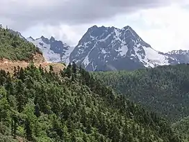 Snow-capped mountains in Diqing Prefecture | |
| Etymology: From Tibetan བདེ་ཆེན (dêqên), meaning "auspicious place" | |
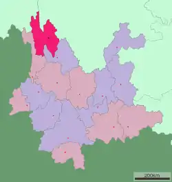 Location of Diqing Prefecture in Yunnan | |
| Country | China |
| Province | Yunnan |
| Prefecture seat | Shangri-La |
| Government | |
| • Type | Autonomous prefecture |
| • CCP Secretary | Gu Kun |
| • Congress Chairman | Gu Kun |
| • Governor | Qi Jianxin |
| • CPPCC Chairman | Du Yongchun |
| Area | |
| • Total | 23,185.59 km2 (8,952.01 sq mi) |
| Population (2010) | |
| • Total | 400,182 |
| • Density | 17/km2 (45/sq mi) |
| Time zone | UTC+8 (CST) |
| Postal code | 674400 |
| Area code | 0887 |
| ISO 3166 code | CN-YN-34 |
| Website | www |
| Diqing Tibetan Autonomous Prefecture | |||||||
|---|---|---|---|---|---|---|---|
| Chinese name | |||||||
| Simplified Chinese | 迪庆藏族自治州 | ||||||
| Traditional Chinese | 迪慶藏族自治州 | ||||||
| |||||||
| Tibetan name | |||||||
| Tibetan | བདེ་ཆེན་བོད་རིགས་རང་སྐྱོང་ཁུལ་ | ||||||
| |||||||
Diqing Tibetan Autonomous Prefecture[lower-alpha 1] is an autonomous prefecture in northwestern Yunnan province, China. Covering an area of 23,870 km2 (9,220 sq mi), it is bordered by the Tibet Autonomous Region to the northwest, Sichuan province to the northeast, and other parts of Yunnan province to the southwest and southeast; Nujiang Lisu Autonomous Prefecture and Lijiang, respectively. Its capital and largest city is Shangri-La.
Diqing Prefecture is divided into three county-level divisions: Shangri-La, Deqin County, and Weixi Lisu Autonomous County. They were all formerly under the administration of Lijiang (located southeast of this prefecture).[1] Diqing Prefecture was established in 1957 and named by its first governor.[1]
Etymology
The prefecture's name is derived from the Tibetan word བདེ་ཆེན (dêqên), which means "auspicious place". In Chinese, the name is written with the characters 迪 (dí) and 庆 (qìng), which mean "to enlighten" and "to celebrate", respectively.[2] Alternate English names include Dechen and Deqing.[3]
Transport
Air
Diqing Shangri-La Airport, also known simply as Diqing Airport, is one of the biggest airports in the northwest of the Yunnan Province. It is located about 3.4 miles (5.5 km) from the center of Shangri-La City. There are flights to Lhasa, Chengdu, Beijing (via Kunming), Shanghai Pudong, Shenzhen (via Guiyang), Guangzhou, Kunming and Xishuangbanna.
Road
Highways are the main means of transportation to reach Diqing Prefecture. The major highway in this prefecture is China National Highway 214 (a Yunnan-Tibet-Qinghai highway abbreviated "G214").
There are also direct bus routes to Kunming, Lijiang and Panzhihua (Sichuan).
Demography
| Ethnicity | Population | Percentage |
|---|---|---|
| Tibetan | 127,685 | 32.95% |
| Lisu | 105,397 | 27.20% |
| Han | 64,823 | 16.73% |
| Naxi | 43,447 | 11.21% |
| Bai | 21,208 | 5.47% |
| Yi | 17,759 | 4.58% |
| Pumi | 2,081 | 0.54% |
| Miao | 1,641 | 0.42% |
| Hui | 1,593 | 0.41% |
| Hani | 251 | 0.06% |
| Others | 1,626 | 0.42% |
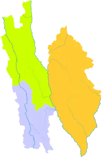
Subdivisions
Diqing Prefecture is divided into three county-level divisions: Shangri-La, Deqin County, and Weixi Lisu Autonomous County.
| Map | |||||||||
|---|---|---|---|---|---|---|---|---|---|
| Name | Hanzi | Hanyu Pinyin | Tibetan | Tibetan Pinyin | Wylie | Population (2010 Census) |
Area (km2) | Density (/km2) | |
| Shangri-La | 香格里拉市 | Xiānggélǐlā Shì | སེམས་ཀྱི་ཉི་ཟླ་གྲོང་ཁྱེར། | Xamgyi'nyilha Chongkyir | sems kyi nyi zla grong khyer | 172,988 | 11,613 | 14.89 | |
| Deqin County | 德钦县 | Déqīn Xiàn | བདེ་ཆེན་རྫོང་།
མཇོལ་རྫོང་། |
Dêqên Zong
Jol Zong |
bde chen rdzong
mjol rdzong |
66,589 | 7,596 | 8.76 | |
| Weixi Lisu Autonomous County | 维西傈僳族 自治县 |
Wéixī Lìsùzú Zìzhìxiàn |
འབའ་ལུང་ལི་སུའུ་རིགས་རང་སྐྱོང་རྫོང་། | Balung Lisurig Ranggyong Zong | 'ba' lung li su'u rigs rang skyong rdzong | 160,605 | 4,661 | 34.45 | |
History
This prefecture is in the southern part of a historical region called Kham, which belonged to the Tibetan Empire many centuries ago. After the decline of that empire in the 9th century, peripheral areas like southern Kham remained part of Tibet more in an ethnographical than a political sense. As a practical matter, by the mid-1700s, the Tibetan Government had mostly lost control of Kham to Manchu (Qing) China and that situation lasted until the end of the Manchu Dynasty in 1912.[4]
Southern Kham along with other parts of Yunnan were ruled by the Yunnan clique from 1915 until 1927. Then it was controlled by Governor and warlord Long (Lung) Yun until near the end of the Chinese Civil War, when Du Yuming removed him under the order of Chiang Kai-shek.
There are three county-level divisions in this prefecture: Shangri-La (formerly Zhongdian), Deqin County and Weixi Lisu Autonomous County (formerly Weixi) and they all were under the administration of Lijiang.[1] The Autonomous Prefecture was established in 1957 and named "Diqing" by its first governor.[1][5]
During the remainder of the 20th century, the prefecture's capital was called Zhongdian but was renamed on December 17, 2001 as Shangri-La City (other spellings: Semkyi'nyida, Xianggelila or Xamgyi'nyilha) after the fictional land of Shangri-La in the 1933 James Hilton novel Lost Horizon, with an eye toward promoting tourism in the area.[6][7]
On June 25, 2007 the Pudacuo National Park was established on 500 square miles (1,300 km2) in this prefecture. On January 11, 2014, there was a major fire in the 1,000-year-old Dukezong Tibetan neighborhood of the capital city Shangri-La, causing much damage and hardship.[8]
Notes
References
- 1 2 3 4 "System Evolution", via official website of Diqing government (in Chinese). Accessed April 25, 2015.
- ↑ "Diqing". Wonders of Yunnan.
- ↑ Barnett, Robert. Lhasa: Streets with Memories, p. 197 (Columbia University Press, 2010).
- ↑ Goldstein, M.C. "Change, Conflict and Continuity among a community of nomadic pastoralists—A Case Study from western Tibet, 1950–1990" in Resistance and Reform in Tibet (eds. Barnett and Akiner. London: Hurst & Co., 1994).
- ↑ Mackerras, Colin and Yorke, Amanda. The Cambridge Handbook of Contemporary China, p. 209 (Cambridge University Press, 1991).
- ↑ Yü, Dan. Mindscaping the Landscape of Tibet: Place, Memorability, Ecoaesthetics, p. 47 (Walter de Gruyter GmbH & Co, 2015).
- ↑ Merkel-Hess, Kate. China in 2008: A Year of Great Significance, p. 255 (Rowman & Littlefield, 2009).
- ↑ "Night fire burns for hours, destroys ancient Tibetan town in southwest China's Shangri-La county". Toledo Blade. January 11, 2014.
External links
- Official Website (in Chinese)
- Yunnan-Diqing via chinadiscover.net.
| Regions |
|  | |||||||
|---|---|---|---|---|---|---|---|---|---|
| Prefectures and counties |
| ||||||||
| |||||||||