Gonbad-e Kavus County
Persian: شهرستان گنبد کاووس | |
|---|---|
County | |
 | |
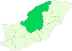 Location of Gonbad-e Kavus County in Golestan province | |
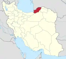 Location of Golestan province in Iran | |
| Coordinates: 37°35′N 55°04′E / 37.583°N 55.067°E[1] | |
| Country | |
| Province | Golestan |
| Capital | Gonbad-e Kavus |
| Districts | Central, Dashli Borun |
| Population (2016)[2] | |
| • Total | 348,744 |
| Time zone | UTC+3:30 (IRST) |
| Gonbad-e Kavus County at GEOnet Names Server | |
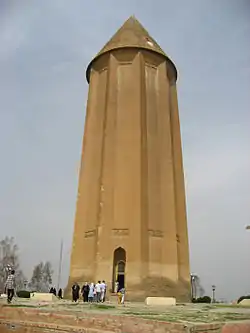
Gonbad-e Kavus County (Persian: شهرستان گنبد کاووس) is in Golestan province, Iran. Its capital is the city of Gonbad-e Kavus, founded by German engineers and architects with high urban engineering standards; by the order of Reza Pahlavi.
At the 2006 census, the county's population was 283,331 in 63,482 households.[3] The following census in 2011 counted 325,789 people in 83,369 households.[4] At the 2016 census, the county's population was 348,744 in 97,147 households.[2]
Formerly called Gorgan or Jorjan, because of the ruins of the historical city called Gorgan, the capital of the Ziyarid dynasty, in its southwest corner. It was called Hyrcania in ancient times.
Administrative divisions
The population history of Gonbad-e Kavus County's administrative divisions over three consecutive censuses is shown in the following table. The latest census shows two districts, six rural districts, and two cities.[2]
| Administrative Divisions | 2006[3] | 2011[4] | 2016[2] |
|---|---|---|---|
| Central District | 261,492 | 300,846 | 320,894 |
| Aqabad RD | 29,707 | 32,907 | 36,886 |
| Bagheli-ye Marama RD | 33,148 | 34,077 | 35,771 |
| Fajr RD | 40,672 | 50,678 | 52,923 |
| Soltanali RD | 30,798 | 38,638 | 43,404 |
| Gonbad-e Kavus (city) | 127,167 | 144,546 | 151,910 |
| Dashli Borun District | 21,839 | 24,197 | 27,181 |
| Atrak RD | 12,468 | 13,405 | 15,244 |
| Kerend RD | 7,607 | 8,511 | 9,443 |
| Incheh Borun (city) | 1,764 | 2,281 | 2,494 |
| Total | 283,331 | 325,789 | 348,744 |
| RD: Rural District | |||
References
- ↑ OpenStreetMap contributors (12 October 2023). "Gonbad-e Kavus County" (Map). OpenStreetMap. Retrieved 12 October 2023.
- 1 2 3 4 "Census of the Islamic Republic of Iran, 1395 (2016)". AMAR (in Persian). The Statistical Center of Iran. p. 27. Archived from the original (Excel) on 29 March 2019. Retrieved 19 December 2022.
- 1 2 "Census of the Islamic Republic of Iran, 1385 (2006)". AMAR (in Persian). The Statistical Center of Iran. p. 27. Archived from the original (Excel) on 20 September 2011. Retrieved 25 September 2022.
- 1 2 "Census of the Islamic Republic of Iran, 1390 (2011)" (Excel). Iran Data Portal (in Persian). The Statistical Center of Iran. p. 27. Retrieved 19 December 2022.
Golestan Province, Iran | ||
|---|---|---|
| Capital |  | |
| Counties and cities | ||
| Sights |
| |
| populated places | ||