Periyasekkadu | |
|---|---|
Neighbourhood | |
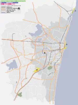
 Periyasekkadu Location in Tamil Nadu, India Show map of Chennai Periyasekkadu Periyasekkadu (Tamil Nadu) Show map of Tamil Nadu Periyasekkadu Periyasekkadu (India) Show map of India | |
| Coordinates: 13°09′36″N 80°15′09″E / 13.159976°N 80.252588°E / 13.159976; 80.252588 | |
| Country | |
| State | |
| District | Thiruvallur |
| Metro | Chennai |
| Zone | Madhavaram Zone No 3 |
| Ward | Periyasekkadu (Ward 28) |
| Elevation | 11 m (36 ft) |
| Languages | |
| • Official | Tamil |
| Time zone | UTC+5:30 (IST) |
| PIN | 600051 |
| Telephone code | 044-2594 |
| Vehicle registration | TN-20-xxxx & TN-18-xxxx(new) |
| Civic agency | Corporation of Chennai |
| Planning agency | CMDA |
| City | Chennai |
Periyasekkadu is a neighbourhood of Chennai in Thiruvallur district in the state of Tamil Nadu, India. Periyasekkadu used to be a part of Madhavaram Municipality in Thiruvallur district. In 2011, Madhavaram Municipality was merged with Chennai Corporation. Periyasekkadu comes under ward 28 in Zone 3 (Madhavaram) of Chennai Corporation.
References
Areas of Chennai | |
|---|---|
| North |
|
| West |
|
| Central |
|
| South |
|
Neighbourhoods of Chennai (city) | |
|---|---|
|
| District headquarters |  | |
|---|---|---|
| Country | ||
| State | ||
| Region | ||
| Revenue divisions | ||
| Taluks | ||
| Revenue blocks | ||
| Municipal corporations | ||
| Municipalities | ||
| Special grade town panchayats | ||
| Town panchayats | ||
| History | ||
| Places of interest |
| |
| Universities |
| |
This article is issued from Wikipedia. The text is licensed under Creative Commons - Attribution - Sharealike. Additional terms may apply for the media files.