Steenberg | |||||||||||
|---|---|---|---|---|---|---|---|---|---|---|---|
| Metrorail station | |||||||||||
 | |||||||||||
| General information | |||||||||||
| Location | Henley Road, Steenberg 7945, Cape Town South Africa | ||||||||||
| Coordinates | 34°04′36″S 18°27′49″E / 34.0767°S 18.4637°E / -34.0767; 18.4637 | ||||||||||
| Owned by | PRASA | ||||||||||
| Line(s) | |||||||||||
| Platforms | island platform | ||||||||||
| Tracks | 2 | ||||||||||
| Connections | Taxis on Retreat-Steenberg-Grassy Park route | ||||||||||
| Construction | |||||||||||
| Structure type | At-grade | ||||||||||
| Parking | approx. 50 spaces | ||||||||||
| Services | |||||||||||
| |||||||||||
| Location | |||||||||||
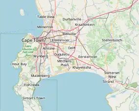
 Steenberg Location in Cape Town Show map of Cape Town Steenberg Location in South Africa Show map of South Africa | |||||||||||
Steenberg railway station is a Metrorail station on the Southern Line in Steenberg, a suburb of Cape Town. It is located on Henley Road, which is just off Military Road. The station is located on the edge of Steenberg, towards Kirstenhof and is alongside the Keyser River, which flows into Zandvlei.
Steenberg has a small taxi rank which only serves Grassy Park and Steenberg. Busses to Cape Town are only available at early times of the morning.
The station has an island platform, connected by a pedestrian bridge over the tracks. In normal operation, Platform 1 (the western platform) is used for trains travelling towards Cape Town, while Platform 2 (the eastern platform) is used for trains travelling towards Simon's Town.
Notable places nearby
This article is issued from Wikipedia. The text is licensed under Creative Commons - Attribution - Sharealike. Additional terms may apply for the media files.