Crémarest | |
|---|---|
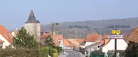 A general view of Cremarest | |
 Coat of arms | |
Location of Crémarest | |
 Crémarest  Crémarest | |
| Coordinates: 50°42′01″N 1°47′10″E / 50.7003°N 1.7861°E | |
| Country | France |
| Region | Hauts-de-France |
| Department | Pas-de-Calais |
| Arrondissement | Boulogne-sur-Mer |
| Canton | Desvres |
| Intercommunality | CC Desvres-Samer |
| Government | |
| • Mayor (2020–2026) | Claude Prudhomme[1] |
| Area 1 | 11.69 km2 (4.51 sq mi) |
| Population | 804 |
| • Density | 69/km2 (180/sq mi) |
| Time zone | UTC+01:00 (CET) |
| • Summer (DST) | UTC+02:00 (CEST) |
| INSEE/Postal code | 62255 /62240 |
| Elevation | 24–108 m (79–354 ft) (avg. 35 m or 115 ft) |
| 1 French Land Register data, which excludes lakes, ponds, glaciers > 1 km2 (0.386 sq mi or 247 acres) and river estuaries. | |
Crémarest (French pronunciation: [kʁemaʁɛ]) is a commune in the Pas-de-Calais department in the Hauts-de-France region of France.[3]
Geography
A farming and forestry village, some 8 miles (13 km) east of Boulogne, at the junction of the D238 and the D254 roads, by the banks of the river Liane.
Population
| Year | Pop. | ±% p.a. |
|---|---|---|
| 1968 | 495 | — |
| 1975 | 486 | −0.26% |
| 1982 | 462 | −0.72% |
| 1990 | 563 | +2.50% |
| 1999 | 658 | +1.75% |
| 2007 | 686 | +0.52% |
| 2012 | 815 | +3.51% |
| 2017 | 786 | −0.72% |
| Source: INSEE[4] | ||
Places of interest
- The church of St. Espirit, dating from the sixteenth century.
- The seventeenth-century chateau of La Freynoye.
- Remains of an old castle.
See also
References
- ↑ "Répertoire national des élus: les maires". data.gouv.fr, Plateforme ouverte des données publiques françaises (in French). 2 December 2020.
- ↑ "Populations légales 2021". The National Institute of Statistics and Economic Studies. 28 December 2023.
- ↑ INSEE commune file
- ↑ Population en historique depuis 1968, INSEE
Wikimedia Commons has media related to Crémarest.
This article is issued from Wikipedia. The text is licensed under Creative Commons - Attribution - Sharealike. Additional terms may apply for the media files.