Lottinghen | |
|---|---|
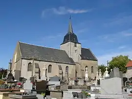 The church of Lottinghen | |
 Coat of arms | |
Location of Lottinghen | |
 Lottinghen  Lottinghen | |
| Coordinates: 50°41′05″N 1°56′00″E / 50.6847°N 1.9333°E | |
| Country | France |
| Region | Hauts-de-France |
| Department | Pas-de-Calais |
| Arrondissement | Boulogne-sur-Mer |
| Canton | Desvres |
| Intercommunality | CC Desvres-Samer |
| Government | |
| • Mayor (2020–2026) | André Leleu[1] |
| Area 1 | 10.11 km2 (3.90 sq mi) |
| Population | 537 |
| • Density | 53/km2 (140/sq mi) |
| Time zone | UTC+01:00 (CET) |
| • Summer (DST) | UTC+02:00 (CEST) |
| INSEE/Postal code | 62530 /62240 |
| Elevation | 68–211 m (223–692 ft) (avg. 163 m or 535 ft) |
| 1 French Land Register data, which excludes lakes, ponds, glaciers > 1 km2 (0.386 sq mi or 247 acres) and river estuaries. | |
Lottinghen (French pronunciation: [lɔtɛ̃ɡɑ̃]) is a commune in the Pas-de-Calais department in the Hauts-de-France region of France.[3]
Geography
Lottinghen is situated about 14 mi east of Boulogne, at the junction of the D204 and D254 roads.
Population
| Year | Pop. | ±% p.a. |
|---|---|---|
| 1968 | 531 | — |
| 1975 | 527 | −0.11% |
| 1982 | 436 | −2.67% |
| 1990 | 457 | +0.59% |
| 1999 | 464 | +0.17% |
| 2007 | 511 | +1.21% |
| 2012 | 553 | +1.59% |
| 2017 | 545 | −0.29% |
| 2020 | 533 | −0.74% |
| Source: INSEE[4] | ||
History
On March 13, 1944, the Ninth Air Force attacked a "V-weapon" site at Lottinghen.
Places of interest
- The church, dating from the seventeenth century.
See also
References
- ↑ "Répertoire national des élus: les maires". data.gouv.fr, Plateforme ouverte des données publiques françaises (in French). 2 December 2020.
- ↑ "Populations légales 2021". The National Institute of Statistics and Economic Studies. 28 December 2023.
- ↑ INSEE commune file
- ↑ Population en historique depuis 1968, INSEE
Wikimedia Commons has media related to Lottinghen.
This article is issued from Wikipedia. The text is licensed under Creative Commons - Attribution - Sharealike. Additional terms may apply for the media files.