Inxent
Enessem | |
|---|---|
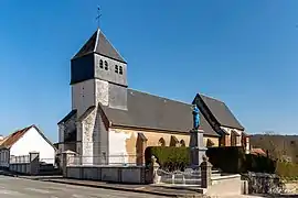 The church of Inxent | |
 Coat of arms | |
Location of Inxent | |
 Inxent  Inxent | |
| Coordinates: 50°32′02″N 1°47′03″E / 50.5339°N 1.7842°E | |
| Country | France |
| Region | Hauts-de-France |
| Department | Pas-de-Calais |
| Arrondissement | Montreuil |
| Canton | Berck |
| Intercommunality | CA Deux Baies en Montreuillois |
| Government | |
| • Mayor (2020–2026) | Dominique Bigand[1] |
| Area 1 | 3.78 km2 (1.46 sq mi) |
| Population | 158 |
| • Density | 42/km2 (110/sq mi) |
| Time zone | UTC+01:00 (CET) |
| • Summer (DST) | UTC+02:00 (CEST) |
| INSEE/Postal code | 62472 /62170 |
| Elevation | 21–113 m (69–371 ft) (avg. 28 m or 92 ft) |
| 1 French Land Register data, which excludes lakes, ponds, glaciers > 1 km2 (0.386 sq mi or 247 acres) and river estuaries. | |
Inxent (French pronunciation: [ɛ̃ksɑ̃]; West Flemish: Enessem) is a commune in the Pas-de-Calais department in the Hauts-de-France region of France.[3]
Geography
A small village situated some 5 miles (8 km) north of Montreuil-sur-Mer on the D127 road, in the valley of the river Course.
Population
| Year | Pop. | ±% p.a. |
|---|---|---|
| 1968 | 190 | — |
| 1975 | 177 | −1.01% |
| 1982 | 170 | −0.57% |
| 1990 | 157 | −0.99% |
| 1999 | 158 | +0.07% |
| 2007 | 155 | −0.24% |
| 2012 | 172 | +2.10% |
| 2017 | 162 | −1.19% |
| Source: INSEE[4] | ||
Places of interest
- The church of the Nativité-de-Notre-Dame, dating from the thirteenth century.
- A partially restored watermill.
See also
References
- ↑ "Répertoire national des élus: les maires". data.gouv.fr, Plateforme ouverte des données publiques françaises (in French). 2 December 2020.
- ↑ "Populations légales 2021". The National Institute of Statistics and Economic Studies. 28 December 2023.
- ↑ INSEE commune file
- ↑ Population en historique depuis 1968, INSEE
Wikimedia Commons has media related to Inxent.
This article is issued from Wikipedia. The text is licensed under Creative Commons - Attribution - Sharealike. Additional terms may apply for the media files.