Les Attaques | |
|---|---|
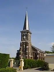 The church of Les Attaques | |
 Coat of arms | |
Location of Les Attaques | |
 Les Attaques  Les Attaques | |
| Coordinates: 50°54′28″N 1°56′05″E / 50.9078°N 1.9347°E | |
| Country | France |
| Region | Hauts-de-France |
| Department | Pas-de-Calais |
| Arrondissement | Calais |
| Canton | Calais-2 |
| Intercommunality | CA Grand Calais Terres et Mers |
| Government | |
| • Mayor (2020–2026) | Nadine Denièle-Vanpouille[1] |
| Area 1 | 20.81 km2 (8.03 sq mi) |
| Population | 2,052 |
| • Density | 99/km2 (260/sq mi) |
| Time zone | UTC+01:00 (CET) |
| • Summer (DST) | UTC+02:00 (CEST) |
| INSEE/Postal code | 62043 /62730 |
| Elevation | 0–6 m (0–20 ft) (avg. 3 m or 9.8 ft) |
| 1 French Land Register data, which excludes lakes, ponds, glaciers > 1 km2 (0.386 sq mi or 247 acres) and river estuaries. | |
Les Attaques (French pronunciation: [lez‿atak]) is a commune in the Pas-de-Calais department in the Hauts-de-France region of France.[3]
Geography
A large farming and light industrial village located 4 miles (6 km) southeast of Calais, at the junction of the N43 and D248 roads. Both the A26 "autoroute des Anglais" and the Calais-St. Omer canal pass through the commune.
Population
| Year | Pop. | ±% p.a. |
|---|---|---|
| 1968 | 1,790 | — |
| 1975 | 1,775 | −0.12% |
| 1982 | 1,878 | +0.81% |
| 1990 | 1,887 | +0.06% |
| 1999 | 1,821 | −0.39% |
| 2007 | 2,039 | +1.42% |
| 2012 | 1,939 | −1.00% |
| 2017 | 1,978 | +0.40% |
| Source: INSEE[4] | ||
Sights

Underside of Les Attaques' four-way bridge
- The church of St. Pierre, dating from the nineteenth century.
- The nineteenth-century chateau Brûlé.
- Vestiges of a Capuchin abbey.
- A rare four-branch bridge
See also
References
- ↑ "Répertoire national des élus: les maires" (in French). data.gouv.fr, Plateforme ouverte des données publiques françaises. 13 September 2022.
- ↑ "Populations légales 2021". The National Institute of Statistics and Economic Studies. 28 December 2023.
- ↑ INSEE commune file
- ↑ Population en historique depuis 1968, INSEE
External links
Wikimedia Commons has media related to Les Attaques.
- Les Attaques official website (in French)
This article is issued from Wikipedia. The text is licensed under Creative Commons - Attribution - Sharealike. Additional terms may apply for the media files.