Savy-Berlette | |
|---|---|
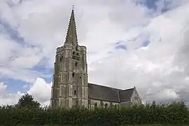 The church of Savy-Berlette | |
.svg.png.webp) Coat of arms | |
Location of Savy-Berlette | |
 Savy-Berlette  Savy-Berlette | |
| Coordinates: 50°21′12″N 2°33′56″E / 50.3533°N 2.5656°E | |
| Country | France |
| Region | Hauts-de-France |
| Department | Pas-de-Calais |
| Arrondissement | Arras |
| Canton | Avesnes-le-Comte |
| Intercommunality | CC Campagnes de l'Artois |
| Government | |
| • Mayor (2020–2026) | Jean-François Varoqui[1] |
| Area 1 | 7.49 km2 (2.89 sq mi) |
| Population | 904 |
| • Density | 120/km2 (310/sq mi) |
| Time zone | UTC+01:00 (CET) |
| • Summer (DST) | UTC+02:00 (CEST) |
| INSEE/Postal code | 62785 /62690 |
| Elevation | 92–138 m (302–453 ft) (avg. 98 m or 322 ft) |
| 1 French Land Register data, which excludes lakes, ponds, glaciers > 1 km2 (0.386 sq mi or 247 acres) and river estuaries. | |
Savy-Berlette is a commune in the Pas-de-Calais department in the Hauts-de-France region of France.[3]
Geography
Savy-Berlette lies 12 miles (19 km) northwest of Arras, at the junction of the D74, D76 and D82 roads.
Population
| Year | Pop. | ±% p.a. |
|---|---|---|
| 1968 | 674 | — |
| 1975 | 616 | −1.28% |
| 1982 | 702 | +1.88% |
| 1990 | 800 | +1.65% |
| 1999 | 854 | +0.73% |
| 2007 | 956 | +1.42% |
| 2012 | 939 | −0.36% |
| 2017 | 916 | −0.49% |
| Source: INSEE[4] | ||
Places of interest
- The eighteenth-century chapel and cemetery portal.
- The church of St.Martin, dating from the sixteenth century.
- The eighteenth-century chateau de Berlette.
See also
References
- ↑ "Répertoire national des élus: les maires". data.gouv.fr, Plateforme ouverte des données publiques françaises (in French). 2 December 2020.
- ↑ "Populations légales 2021". The National Institute of Statistics and Economic Studies. 28 December 2023.
- ↑ INSEE commune file
- ↑ Population en historique depuis 1968, INSEE
Wikimedia Commons has media related to Savy-Berlette.
This article is issued from Wikipedia. The text is licensed under Creative Commons - Attribution - Sharealike. Additional terms may apply for the media files.